 Friends of Gualala River Protecting the Gualala River watershed and the species living within it
Patrick Higgins
Consulting Fisheries Biologist
791 Eighth Street, Suite N
Arcata, CA 95521
(707) 822-9428
phiggins@humboldt1.com
July17, 2004
Allen Robertson, Deputy Chief
California Department ofForestry and Fire Protection
P.O. Box 944246
Sacramento, CA 94244-2460
Re: Negative Declaration for Timber Harvest Plan (THP 1-04-059)/ Martin Timberland Conversion Permit (TCP 04-531)
Dear Mr. Robertson,
I am writing in regards to TimberHarvest Plan (THP) 1-04-059/ Martin TimberlandConversion Permit (TCP) 04-531 at the request of, and on retainer tolocal citizens, who are concerned about the deterioration of the Gualala Riverwatershed. I have read THP 1-04-059/TCP 04-531 andthe Negative Declaration from the California Department of Forestry (CDF),as well as related information (Baye, 2004; Erman, 2004; Poehlman and Lavine;Plum, 2004, Barbour, 2004). I would like to incorporate by reference mycomments recently filed on other THP/TCP projects in the Gualala River basinalso given Negative Declarations by CDF:
· May 20, 2003 on the Artesia TimberlandConversion Permit 02-506 and Timber Harvest Plan (THP) 1—01-171 SON, which wasalso near Annapolis on Patchet Creek, a tributary to the Wheatfield ForkGualala (Higgins, 2003a),
· In December 2003 on the Seaview TimberlandConversion Permit 524 and Timber Harvest Plan (THP) 1-01-223 SON (Higgins,2003b) in the upper South Fork Gualala River basin, and
· April 14, 2004 on THP1-04-030SON, Hanson/Whistler Timberland Conversion Permit (TCP) #530 (Higgins, 2004).
The CDF Negative Declarationfails to recognize the advancements in knowledge of cumulative watershedeffects (CWE) in northwestern California as embodied by works such those ofLigon et al. (1999), Dunne et al (2001) and Collison et al. (2003). Thesestudies recognize that CDF’s fragmented approach to analysis is not preventingCWE and related loss of biodiversity, such as Pacific salmon species. Recentregional studies of Pacific salmon status and trends are not acknowledged ortheir relevance discussed (NMFS, 2001; CDFG, 2003). The THP/TCP does notcredibly characterize existing impacts within the Little Creek CalwaterPlanning Watershed, let alone the Gualala River basin as a whole. The THP/TCPonly mentions the Gualala River Total Maximum Daily Load (CSWRCB, 2001) studyin passing without acknowledging its findings of major existing sedimentproblems. The THP/TCP claims that there will be no sediment and flow impactsfrom this land use activity, which is not possible. The Registered ProfessionalForester (Jacobszoon, 2004) and the CDF Negative Declaration fail to providedata or credible science-based discussions of potential changes in flowassociated with conversion of intact forest land to vineyard. The aboveomissions and problems should have caused you to decline Negative Declarationon status on THP 1-04-059/TCP 04-531 inaccordance with the California Environmental Quality Act (CEQA).
My Qualifications
I have been a consultingfisheries biologist for the last 15 years with an office in Arcata, California.My academic training includes both completion of a B.S. in Biology fromHumboldt State University awarded in 1975 and graduate work in fisheries at thesame institution from 1985-1989. In 1992, I served as lead author of FactorsThreatening Stocks with Extinction in Northwestern California (Higgins et al., 1992), a peer reviewed positionpaper for the American Fisheries Society on regional Pacific salmon. I alsohave expertise in Pacific salmon restoration and have written elements ofrestoration plans for river basins in California including the: Klamath River(Kier Assoc., 1991), South Fork Trinity River (Pacific Watershed Associates,1994), Garcia River (Monschke and Caldon, 1991) and San Mateo Creek and theSanta Margarita River (Higgins, 1992). In 1997, I conducted an assessment ofthe Gualala River based on existing literature (Higgins, 1997) for the RedwoodCoast Land Conservancy. Since 1992, I have been working on comprehensivewatershed databases for numerous Northern California basins. That project beganin the Klamath, after which the project was named (Klamath Resource InformationSystem or KRIS). A number of KRIS projects have been sponsored by CDF,including ones for the Noyo, Big, Ten Mile, Mattole and Gualala rivers. The KRISGualala project provides data that is in part the basis of these comments,including fisheries, water quality, timber harvest, vegetation types, roads andriparian conditions.
Fisheries
The environmental reviewdocuments submitted by the Registered Professional Forester (RPF) for thisproject (Jacobszoon, 2004) state that its watershed area of analysis (WAA) isthe Little Creek Calwater Planning Watershed (5,869 Acres), yet they give onlythe barest fisheries information regarding Buckeye Creek, the lower reaches ofwhich are within it, or Little Creek itself. The National Marine FisheriesService (NMFS, 2001), the California Department of Fish and Game (CDFG, 2002)and Brown et al. (1994) have found that coho salmon (Oncorhynchus kisutch)are at risk of extinction throughout Mendocino and Sonoma County. The THP/TCPnotes that coho are absent in the WAA and refers to its Federally Threatenedonly through an abbreviation. It completely skips discussions of theimplications of habitat changes related to the proposed activities andprospects for recovery of at risk salmonid species in the Gualala basin andregionally. Coho were once known to be abundant in the Gualala River (Taylor,1972) yet CDFG (CA RA, 2002) surveyed over 100 miles of stream in the Gualalabasin and collected fish samples using electroshocking and found no coho salmonanywhere. CDFG (2002) acknowledges that coho in the Gualala basin are“extirpated or nearly so.” The status of the steelhead trout (Oncorhynchusmykiss) is again referred to in the THP/TCP only through abbreviation.There are no discussions of substance as to reason for listing as Threatenedunder the Endangered Species Act (Busby et al., 1996; NMFS, 1996), theirprospects for recovery in the Gualala, and the proposed actions effects onthose prospects.
The THP/TCP does not mentionthat coho salmon were likely to have inhabited lower Little Creek and lowerBuckeye Creek, have been extirpated and are not likely to be restored unlessstreams are allowed to recover. Groot and Margolis (1991) note that coho salmonprefer streams in the range of 1-2% gradient or less for spawning and rearingand data from the KRIS Gualala project show that Buckeye Creek and lower LittleCreek fall within this range (Figure 1). Steelhead can actually leap 15 feetvertically and are known to inhabit reaches with higher gradient. The THP/TCPsays they exist only in the lowest reach of Little Creek, but provides notsupporting data. This activity is likely to further decrease suitability forcoho salmon and steelhead by increasing sediment, decreasing base flows andincreasing peak flows, and elevating water temperatures directly or indirectly(see discussions below).
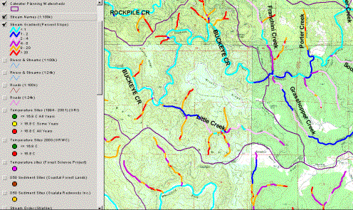
Figure 1. Gradient of BuckeyeCreek and Little Creek as depicted by maps generated from CDF elevation data inKRIS Gualala. These data show that both streams would be suitable for cohosalmon in their lower reaches.
The KRIS Gualala project(IFR, 2002) advanced an hypothesis that the distribution and abundance of cohosalmon and steelhead have decreased in the Gualala River basin, citing evidenceof stream segments that were buried or so impaired as to lack depth, substrateconditions or appropriate water
temperature to support thesesensitive species. This and other hypotheses advanced by IFR (2003) were peerreviewed with oversight from the University of California (Standiford, 2003)and reviewers said that the arguments offered were supported by the availableliterature and data. CDFG (CA RA, 2002) electrofishing samples included fewolder age steelhead trout juveniles, with smaller Gualala River tributariesbeing too shallow to support summer rearing of larger fish, and larger streamstoo warm (IFR, 2003). Barnhart (1986) noted that northern California steelheadmost often spend two years in freshwater before going to the ocean. If fish donot attain a large size before ocean entry, their likelihood of survival in theocean is quite low.
Despite steelhead trout beingnoted as present in Little Creek, the THP/TCP presents no fish sampling data toindicate the level of present use or standing crops. Given the depressed statusof this species regionally and in the Gualala River basin, the THP/TCP shouldacknowledge if this stream has higher carrying capacity than Buckeye Creek itselfand what role it serves in potential protection and recovery of steelhead atboth scales. The THP/TCP notes that “the small number of deep pools” makes thelocal streams “marginal” for coho salmon juvenile rearing, but there are noquantitative data with which to judge present fish habitat quality in LittleCreek such as pool frequency and depth, substrate conditions, large woodavailability and riparian canopy conditions. Without these data one cannotjudge potential impacts on coho salmon and steelhead populations of this andother land use activities. Lack of baseline data also prevents futuremonitoring to judge aquatic response to land use over time.
Water Temperature ofBuckeye Creek and Gualala River and Suitability for Salmonids
As discussed in my previouscomments on other Gualala River THP/TCP projects (Higgins, 2003a; 2003b; 2004),smaller tributaries in the Gualala Basin like Little Creek are likely to sufferless temperature impairment than larger order streams like Buckeye Creek (Figure2). If Little Creek is summer periods when water temperatures in larger GualalaRiver tributaries often exceed stressful or lethal levels (Sullivan et al.,2001). Optimum temperatures for steelhead are between 10-15 degrees Celsius (C)and data from KRIS Gualala (Figure 3) show that mainstem Buckeye Creek watertemperatures are well over stressful for steelhead (McCullough, 1999) and wellbeyond the range needed for coho salmon rearing (Welsh et al., 2001).
Figure 2. Water temperaturesuitability for coho salmon is displayed above from the KRIS Gualala projectshowing that the mainstem of Gualala River and its larger tributaries,including Buckeye Creek, are too warm in all years (red). Only two smalltributaries of lower Rockpile Creek and the Wheatfield Fork were found to besuitable in all years measured (green), although these streams are likely toosmall and steep to support the species.
Poole and Berman (2000) noteanthropogenic mechanisms that change water temperature regimes and at least twoapply to the current project. The proposed project will likely exacerbate watertemperature problems by: 1) additional sediment contributions that fill poolsand increase the width to depth ratio facilitating heat exchange with theatmosphere (see Sediment), and 2) reducing cool water base flows in summerbecause of how the project will alter flow regimes (see Flows).
If Little Creek is lessimpacted by sediment and has cooler water temperature regimes than other nearbystreams, its alteration could be extremely deleterious for near term prospectsof steelhead recovery and longer term prospects for coho recovery in thisportion of the Gualala River basin. Coho should be recognized as the mostcritical “beneficial use” associated with cold water fish under the Clean WaterAct in the Gualala River and long term goals should be to return the westerntributaries to coho suitability (<16.8 C MWAT). Continuing timber harvestsand conversions will have the opposite effect.
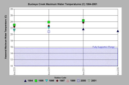
Figure 3. This chart fromKRIS Gualala shows the maximum water temperature for all automated temperatureprobes placed in the Buckeye Creek from 1994 to 2001 with temperatures welloutside the optimal range for salmonid rearing and rather in the range ofhighly stressful or lethal. Data provided by Gualala Redwoods, Inc. and theGualala River Watershed Council.
Sediment Levels andSources Not Acknowledged in THP/TCP
THP 1-04-059/TCP 04-531 (Jacobszoon, 2004) states that most sedimentimpacts in the Gualala River basin are from long-past logging carried outbefore the passage of the California Forest Practice Rules in 1972. TheGualala River watershed is listed as impaired for sediment under section 303(d)of the Federal Clean Water Act (NCRWQCB, 2003). The Technical SupportDocument for the Gualala River Watershed Water Quality Attainment Action Planfor Sediment (CWQCB, 2001) found thathuman caused sediment delivery rates are approximately 200% above the naturalbackground level in the Buckeye Creek basin (Figure 4).
Roads are the most significantcontributor of sediment in Buckeye Creek and basin-wide (CWQCB, 2001) and roaddensities in the Gualala River watershed over-all are high, including theBuckeye watershed (Figure 5). Road densities in the Little Creek CalwaterPlanning Watershed, which encompasses lower Buckeye Creek and all of LittleCreek has some of the highest road densities in the Gualala River basin at over8 miles per square mile (mi/mi2). Road density data are conservativebecause temporary roads, skid trails and landings may not be mapped. AllBuckeye sub-basins exceed by a large margin the threshold of 2.0 mi/mi2,with no streamside roads, defined by NMFS (1996) as properly functioningwatershed conditions for Pacific salmon. The USGS topographic map of LittleCreek itself shows logging roads paralleling the entire stream, sometimes onboth sides of the stream. Cedarholm et. al. (1981) found that road densitiesgreater 4.2 mi/mi2 yielded sediment levels 260% to 430% higher thanbackground levels. Jones and Grant (1996) noted that interception ofsub-surface flows by road cuts as a major factor in increasing peak flowsduring storm events. THP 1-04-059/TCP 04-531 does not give specific road lengths in miles,but states that between 2.5 and 3 acres of roads will be constructed. Thiswould be expected to increase both sediment yield and peak flows in the LittleCreek basin.
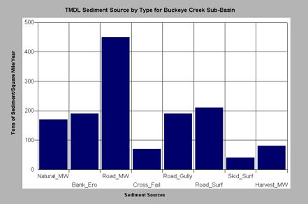
Figure 4. The Buckeye Creekbasin sources of sediment estimated by the CSWRCB (2001). Road sources had thehighest sediment yield in combination. Estimated sediment yield is shown astons of sediment yielded per square mile per year. Chart from KRIS Gualala.
Figure 5. This chart fromKRIS Gualala shows the density of roads in miles per square mile for BuckeyeCreek watershed with a reference line of 2.5 mi/sq. mi which is slightly aboveNMFS (1996) properly functioning watershed condition level for Pacific salmon. LittleCreek has one of the highest road densities in the Gualala River basin. Datafrom UC Davis ICE and North Coast Regional Water Quality Control Board.
With regard tothe THP/TCP’s inference that all sediment sources are old, IFR (2002) advancedthe following hypothesis in KRIS Gualala: “Continuingsediment contributions to the Gualala River and its tributaries from recentland use (1985-2001) are preventing recovery of coho salmon and steelheadhabitat.” This hypothesis was supported by several lines of evidence: smallmedian particle size distribution (Dietrich et al., 1989; Knopp, 1993),increasing fine sediment in size classes with potential to prevent successfulsalmonid spawning (McHenry et al., 1994) and decreased pool volume, frequencyand depth (Knopp, 1993; Entrex, 1994; CDFG, 2001). It was also evaluated andvalidated by the U.C. Berkeley appointed peer review panel funded by CDF’s Fireand Resource Assessment Program (FRAP) in Sacramento (Standiford, 2003).
Sediment Impacts onAquatic Ecosystems Evident in Buckeye Creek and Gualala River Basin
There has been a substantialamount of data collected in the Gualala River basin that can be used to judgethe health of streams (CA RA, 2001; Knopp, 1993), much of which has beencaptured in KRIS Gualala. Results of various surveys and their significance aredescribed below.
Mean Particle Size (D50):The median size of stream bed gravels (D50) can be used to characterize streamhealth (Knopp, 1993). Small median particle size may lead to bed loadinstability, which may cause mortality salmon or steelhead eggs when bed loadtransport occurs during their gestation (Nawa and Frissell, 1990). Dietrich etal. (1989) point out that small particles on stream beds are extremely mobileand, if the median particle size distribution of substrate is small, then it islikely that active erosion in the watershed recently contributed sediment. Knopp(1993) studied 60 streams in northwestern California and found that watershedswith a history of high intensity timber harvest management had a D50 of below37 mm in diameter. Data from KRIS Gualala show that most sites measured in thewestern Gualala River basin were below the 37 mm threshold indicating highimpairment likely related to recent, active timber harvest and road building(Figure 6). The reference lines shown on Figure 6 show undisturbed or recoveredvalues for D50 from Knopp (1993), which range from 52 mm to 88 mm.
Fine Sediment in SpawningGravels: Small sediment particles less than 0.85 mm are known to infiltratesalmon and steelhead nests, which are excavated in the stream bed gravels, andgreatly decreasing survival due to smothering of the eggs (McNeil and Ahnell,1964). Gualala Redwoods Inc. collected fine sediment data in the North ForkGualala from 1992 to 1997. The North Fork Gualala River watershed wasundergoing rapid timber harvest and a substantial increase in its road network(see CWE discussions below). Gravel grab samples showed a sharp increase infine sediment less than 0.85 mm (Figure 7), from 10-12% of the stream bed to ashigh as 28%. McHenry et al. (1994) found that, when fine sediment (<0.85 mm)comprised 13% or greater of the substrate inside redds, it caused the mortalityof steelhead and coho salmon eggs. The Gualala River TMDL (CSWRCB, 2001) set14% as a target for fine sediment in accordance with this knowledge ofpotential harm to salmonid spawning. Extensive logging, road building andconversions have taken place in the lower Buckeye Creek basin (see CWEdiscussions below), but no fine sediment data have been collected. Photos fromthe NCRWQCB staff (Figure 8), however, show that some adjacent tributaries likeFranchini Creek are choked with fine sediment. This not only shows thatsediment is of recent origin, but also illustrates CWE in this nearby basin notacknowledged by Jacobszoon (2004).
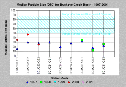
Figure 6. Median particlesize distribution of stream gravels from KRIS Gualala show that almost allsites measured within the Buckeye Creek watershed were at levels indicatingsediment impairment (Knopp, 1993). Data from Gualala Redwoods, Inc.
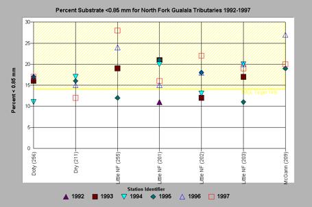
Figure 7. Fine sediment lessthan 0.85 mm exceeded levels recognized to be harmful to salmonid egg survivaland the TMDL recognized threshold of 14% in Doty and Dry creeks, McGann Gulchand the Little North Fork Gualala River, with mostly increasing trends duringthe period of record. Data from Gualala Redwoods Inc.
Figure 8. Franchini Creek,tributary to lower Buckeye Creek and NCRWQCB staff during 2001 surveyindicating major sediment problems and recent, active contributions. This isnot viable salmonid spawning or rearing habitat. Photo by Brian McFadin.
Volume of Sediment inPools (V-Star): Knopp (1993) found that northern California streamsdraining watersheds with high timber harvest management had higher levels of sedimentin pools. He used a method of measuring pool volume relative to sediment knownas the V-star method (Hilton and Lisle, 1992). Values measured are roughlyequivalent to the percent of the pool volume filled by sediment. Figure 9 showsV-star values for six pools measured in Grasshopper Creek, the tributary to theeast of Little Creek that had a V-star score of 0.59. This indicates a highdegree of impairment from sediment and is far above the TMDL target set for theGualala River basin of less than 0.21 (CSWRB, 2001). Again Jacobszoon (2004)failed to note sediment impairment and to meet the standard for use of bestavailable science under CEQA.
Pool Frequency and Depth:The California Department of Fish and Game (1998) describes a method of streamhabitat inventory known as habitat typing. Pool frequency by length and depthfrom these surveys can be used as an index of habitat suitability forsalmonids. Optimal quality salmonid streams have 50% or more of their length inpool habitat (CDFG, 1998). Survey results from the Gualala River basincollected by CDFG in 2001 (CA RA, 2002) indicate many tributaries of theGualala River have less than 20% pool frequency by length (Figure 10), whichindicates major problems with sediment filling pools (Reeves et al., 1993). Thehigh amount of dry channel is indicative of severe aggradation where surfaceflows are lost because the stream bed is buried so deeply. THP 1-04-059/TCP 04-531 acknowledges that “coho salmon habitat withinthe assessment area is marginal due to the small number of deep pools,” butfails to link this to any proposed action or long term plan for the recovery ofhabitat for this species and steelhead.
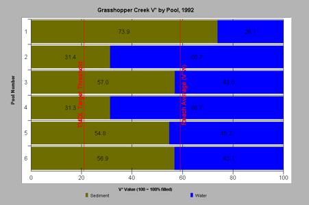
Figure 9. V-star values inGrasshopper Creek as collected by Knopp (1993) indicating major sedimentproblems likely related to logging in this Buckeye Creek tributary adjacent toLittle Creek. Reference of 0.21 V* is from CSWRCB (2001). Chart from KRISGualala.
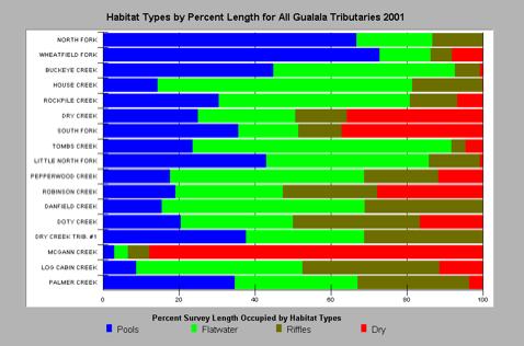
Figure 10. This chart fromKRIS Gualala shows habitat frequency by length from 2001 CDFG habitat typingsurveys of over 100 miles of Gualala River reaches or tributaries.
Although the pool frequencyof for Buckeye appears as if the stream might be in moderate health, pool depthis lacking. Brown et al. (1994) recognize pools greater than three feet indepth as optimal rearing habitat for coho salmon. Larger, older age steelheadalso prefer deeper pools (Reeves, 1988), which provide better cover frompredators. Gualala River tributaries measured by CDFG (CA RA, 2002) show thatmore than 80% of pools in Buckeye Creek are less than 3 feet deep (Figure 12).This finding is very surprising because the stream is a fourth order stream(Strahler, 1957) and has a large watershed and discharge. It is likely thatBuckeye Creek would scour deep pools if there were not an over-supply ofsediment from tributaries, such as Grasshopper and Franchini creeks. The surveyon Buckeye Creek by CDFG in 2001 is the reach beginning at Little Creek andextending down to the lower South Fork Gualala River (Figure 11). This iswithin the Little Creek Calwater Planning Watershed yet Jacobszoon (2004) failsto make reference to either these data or their significance. Buckeye Creekcannot take more sediment at this time and remain viable steelhead habitat andsediment should be reduced to ultimately allow recovery of coho salmon.
The lack of propercharacterization of existing sediment problems in Buckeye Creek and itstributaries make THP 1-04-059/TCP 04-531 insufficientin terms of proper CWE analysis. Figure 11 also shows the acute problemswith sediment and CWE as reflected by lack of deep pools in adjacent RockpileCreek and in the South Fork and Wheatfield Fork of the Gualala River. The lackof pools is clear evidence major problems with sedimentation of streams and nofurther land use contributing sediment should be allowed in the Gualala Riverbasin until pool frequency and depth have recovered to those suitable forsalmonids.
Timber Harvest andCumulative Watershed Effects
Timber harvest rates inGualala River Calwater Planning Watersheds between 1991 and 2001 show that somesub-basins have been harvested at rates as high as 78% (Figure 12). Reeves etal. (1993) pointed out that logging in over 25 % of a watershed’s area in lessthan 30 years compromised aquatic habitat diversity and cause loss of diversityof Pacific salmon species. CDFG (CA RA, 2001) habitat typing data showed thatpool frequency by length was low in recently harvested basins, a result similarto that described by Reeves et al. (1993). All Buckeye Creek Calwater PlanningWatersheds are over this prudent level of disturbance of 25% timber harvest injust ten years of records provided by CDF and harvest was active in the 1980’s.Therefore, cumulative watershed effects from this land use were underestimatedby CA RA (2001). The location of permitted timber harvests are displayed inFigure 13, which also shows the number of road-stream crossings. Armantrout etal. (2001) note that road stream crossings should be limited to one per mile toreduce risk of sediment yield. There appear to be five crossings inapproximately three miles of stream on Little Creek, which indicates it is overthis CWE threshold as well.
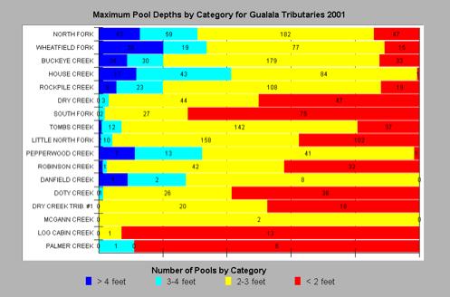
Figure 10. The habitat typingresults from over 100 miles of CDFG surveys in 2001 show that pools deeper thanthree feet are rare on smaller tributaries and even on some mainstem GualalaRiver reaches like the South Fork. Chart from KRIS Gualala.
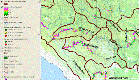
Figure 11. This map imageshows pool depth in lower Buckeye Creek, lower Rockpile Creek and part of thelower Wheatfield and SF Gualala River according to CDFG (2001) data. Note thatthe majority of pools in Buckeye Creek are 2 feet deep or less.
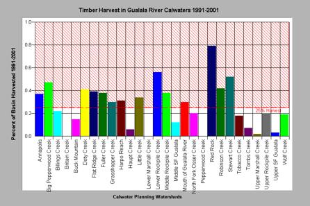
Figure 12. The timber harvestin all Gualala River Calwater Planning Watersheds from 1991-2001 is shown aboveas percentage of watershed area. Half of the basins are more than 25% cut injust over ten years, including all Buckeye Creek Calwaters (Little,Grasshopper, Harpo and Flat Ridge) except NF Osser Creek. Data from CDF, SantaRosa.
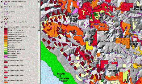
Figure 13. This map imagecomes from the KRIS Gualala ArcView project and shows THP’s approved by CDFfrom 1991-2001, including harvest type. Road-stream crossings are shown as pinkdots with five shown on Little Creek in a reach less than three miles long.
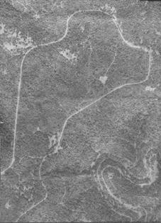
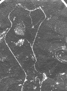
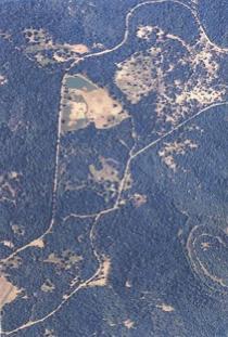
Another troubling aspect ofthe THP 1-04-059/TCP 04-531 application is itsfailure to acknowledge major removal of timber in the Little Creek watershedproper that does not appear as part of CDF THP records (Figure 14). GualalaRiver residents concerned about land use activities in the Little Creekwatershed and the Annapolis vicinity provided aerial photo documentation ofun-permitted harvests in the area affected by the THP 1-04-030SON, Hanson/WhistlerTimberland Conversion Permit (TCP) #530. Theseimpacts are not noted by Jacobszoon (2004) nor by the CDF Negative Declaration,yet they appear large enough to contribute significantly to problems similar tothose that would be generated by THP 1-04-059/TCP04-531. Kauffman et al. (1999) point out that riparian areas andwatersheds can only recover when anthropogenic stressors are ameliorated. Thisconversion and timber harvest is particularly ill-timed because of the alreadywidespread nature of watershed disturbance from timber harvest and roads atthis time.
THP 1-04-059/TCP 04-531 states that “Adherence to plan elements shouldresult in similar erosion potential for both pre and post-constructionconditions.” Collison et al. (2003) note that all timber harvest and roadbuilding have significant sediment impacts even under current California FPR’s.Dunne et al. (2001) point out that in fact widespread disturbance, asdocumented here for the Buckeye Creek, Little Creek and Gualala Riverwatersheds, have major impacts that this THP/TCP and CDF’s Negative Declarationdo not acknowledge:
“Generallyspeaking, the larger the proportion of the land surface that is disturbed atany time, and the larger the proportion of the land that is sensitive to severedisturbance, the larger is the downstream impact. These land-surface andchannel changes can: increase runoff, degrade water quality, and alter channeland riparian conditions to make them less favorable for a large number ofspecies that are valued by society. The impacts are typically most severe alongchannels immediately downstream of land surface disturbances and at thejunctions of tributaries, where the effects of disturbances on many upstreamsites can interact.”
In the Fisheries sectionabove, it was pointed out that 1-04-059/TCP 04-531does not deal sufficiently with endangered and threatened Pacific salmon andDunne et al. (2001) point out that at risk populations can be lost, ifcumulative effects are ignored and anthropogenic stressors continued:
“Cumulative impacts can result fromindividually minor but collectively significant projects taking place over aperiod of time. They may occur at a site through repetition of a change causedby successive operations, or through two or more results of an operation, orthey may occur at a site remote from the original land transformation and withsome time lag. The concern about cumulative effects arises because it isincreasingly acknowledged that, when reviewed on one parcel of terrain at atime, land use may appear to have little impact on plant and animal resources.But a multitude of independently reviewed land transformations may have acombined effect, which stresses and eventually destroys a biological populationin the long run.”
Dunneet al. (2001) also point out that CWE must be managed by minimizing risk:“Inevitably, the institutional aspects involve decisions about how muchenvironmental and other risks are acceptable in a project. Before theinstitutional evaluation can be made, however, the risks of CWEs need to beidentified in some transparent manner.” The lack of provision of sufficientinformation on which to judge impacts of 1-04-059/TCP04-531 fails the test of transparency. CDF should be rejecting this projectbecause the high existing impacts and additional threats posed by previouslypermitted or completed projects, or at least calling for a full EnvironmentalImpact Statement (EIS).
|
|
|
|
Figure 14a. Area of THP 1-04-030SON/TCP #530 in 1990 showing almost complete cover, but high road and skid trail densities. |
Figure 14b. This photo shows the same area as Figure 14a in 1996 with major changes in vegetation, but no THPs filed. |
|
|
Figure 14c (At left): The 2002 aerial photo shows major new openings and substantial thinning of forests, again with no record from CDF for timber harvests on file. This type of large scale vegetation removal is a clear cut equivalent in places and likely already contributing to changes in runoff patterns (Jones and Grant, 1996), even without further conversion to vineyards. |
Flow Issues
The hydrologic review of THP1-04-059/TCP 04-531 is not complete orcredible. It makes a number of unfounded assertions and provides no flowmeasurement data from Little Creek for assessing impacts of the project orjudging their importance in supporting fish life. The THP/TCP notes that cohosalmon are absent in the project WAA, that habitat for them is judged asmarginal due to “inconsistent flow levels”, yet makes no attempt to relate thatinformation back to the plans. Jacobszoon (2004) makes many misstatementsrelated to flows:
· “Surface flow will occur duringwinter months and is unavailable during low flow summer conditions with orwithout project implementation.”
· “There is no scientifically validway to directly correlate well water levels or yield in any area with localrainfall patterns or with surface runoff patterns.”
· “The hydraulic impacts of any wellare limited to a cylindrical zone of tens to a few hundred feet in proximity tothe bore hole…”
A report by Kamman Hydrologyand Engineering (2003), which was written in response to a similar GualalaRiver THP/TCP, reflects a more scientific approach to the question of theaffect on flow of vineyard development in headwater swales. Jacobszoon’s (2004)characterization of ground water infiltration as being unimportant ingroundwater recharge has no scientific support (CDWR, 2003). Associationsbetween rainfall, runoff and infiltration can be calculated, but such studieshave not been carried out in the Gualala River basin. Again the assertion byJacobszoon (2004) that the potential zone of influence for the wells proposedbeing limited to tens or hundreds of feet has no support (CDWR, 2003).Jacobszoon (2004) states erroneously that watershed size dictates base flow andimplies that water withdrawal from a well could not decrease the surface flowsbecause of lack of a groundwater connection, yet provides no data to supportthis contention.
Kamman Hydrology andEngineering (2003) note the importance of infiltration in wild land hydrologyand ground water recharge. Head water springs may be an important source ofwater during low flows of summer. Jacobszoon (2004) notes that “abackhoe/excavator shall be used to construct a diversion from a spring to anadjacent Class III watercourse.” Activities around headwater springs with heavyequipment are likely to disrupt groundwater recharge and natural connectionsbetween spring areas and streams below. Cold water base flows in summer arecritical to the maintenance of steelhead trout and their further disruptionwill make the eventual recovery of coho salmon less likely. CDF does not have the experience or expertise in this areato properly evaluate changes in flow related to vineyard development. Changes in hydrology and flow diversions or reductions,such as those likely to occur under THP 1-04-059/TCP 04-531, should require a fullscale EIS under CEQA.
Leopold and McBain (1995)also pointed out that wide spread compaction related to timber harvest in theGarcia River basin elevated winter runoff. This finding is similar to Jones andGrant (1996) who estimated that, when 25% of the area of a basin were impactedby timber harvest and roads, flow increases of 50% resulted. They note thatincreased peak flows can scour riparian areas, potentially elevating watertemperatures. The increase in peak flows likely associated with roadconstruction are noted above. IFR (2002) advanced a hypothesis that coho salmonand steelhead recovery are limited by summer low flows in the Gualala Riverbasin. Both Jacobszoon (2004) and CDF in their Negatively Declaration fail tonote that extensive reaches of the Gualala River currently lack surface flowbecause of severe aggradation, yet many of these reaches once supportedstanding crops of older age steelhead. No further diversions in the Gualala Riverbasin should be allowed until sediment has been flushed from the system andsurface flows restored in formerly productive reaches and tributaries.
Conclusion
Despite CDFhaving spent hundreds of thousands of dollars in public money to build toolsfor watershed analysis in the Gualala River basin (IFR, 2003), these data seemto be ignored by CDF regional staff when reviewing land use plans, such as Timber Harvest Plan 1-04-059 SON and the Martin Timberland Conversion Permit 04-531. I am enclosing a copyof the KRIS Gualala database and companion ArcView electronic map project,although much of this information is also available over the Internet at www.krisweb.com. CEQA calls for use of thebest available scientific information in planning processes and the CDFNegative Declaration for these plans certainly does not meet that criteriabecause it ignores a great deal that exists.
The extremelypoor health of the Gualala River watershed and Buckeye Creek sub-basin areignored by Jacobszoon (2004) and CDF. TheGualala River is losing its ability to support coho salmon and steelhead trout.Sediment over-supply is evident in the mainstem of Buckeye Creek and itstributaries in the vicinity of the plan. No data are supplied for Little Creekitself with regard to its current condition.
Rieman et al. (1993)characterize a salmonid population as at moderate risk of extinction when:
“Fine sediments, stream temperatures, or theavailability of suitable habitats have been altered and will not recover topre-disturbance conditions within one generation (5 years). Survival or growthrates have been reduced from those in undisturbed habitats. The population isreduced in size but no long-term trend in abundance exists.”
The conditionsdescribed above fairly characterize the Gualala River and its steelheadpopulation, while the coho population would merit a high risk classification(CDFG, 2002). This level of risk is nowhere acknowledged in the THP/TCP anddiscussions do not even include data from the effected tributary Little Creek,which may be a key cold water refuge for steelhead juveniles.
This project is likely todecrease ground water recharge and thus reduce base flows in summer needed bysalmonids. The reduced cold water flow will also increase problems withelevated water temperature. Increased sediment from the site will alsocontribute to stream warming as it reduces the width to depth ratio of LittleCreek and Buckeye Creek below and increases opportunities for heat exchangewith the atmosphere. Impacts from these projects, coupled with existing highlevels of disturbance and existing problems with aquatic health, are likely tohave dire consequences for the prospect of salmonid recovery in the GualalaRiver basin.
Additionaltimber harvests in the Gualala River basin, and especially vineyardconversions, should not go forward until water temperature and sedimenttransport have returned to unimpaired levels and salmonid productivity has beenrestored. This timber harvest andconversion, in combination with others already permitted, are highly likely tonegatively impact recovery prospects for coho salmon and steelhead in the basinand will help continue the trend toward increased sediment, increased watertemperatures and decreased surface flows. Ultimately the entire aquaticcommunity of the Gualala is at risk from such activities, including non-listedspecies like the Sacramento sucker (Higgins, 2003b), as more of the river willlose surface flow. The Negative Declaration should be withdrawn and a full EISrequired.
Sincerely,
PatrickHiggins
References
Barbour, J. 2004. Letter toWayne Burgstahler regarding water needs of vineyards near Annapolis, CA. Barbour Vineyards Management and Development, St. Helena, CA. 1 p.
Barnhart,R. A. 1986. Species profiles: Life histories and environmental requirements ofcoastal fishes and invertebrates (Pacific Southwest)–steelhead. U.S. FishWildlife Service Biological Report. 82(11.60), 21 p.
Brown, L.R., P.B. Moyle, andR.M. Yoshiyama. 1994. Historical Decline and Current Status of Coho Salmon inCalifornia. North American Journal of Fisheries Management. 14(2):237-261.
Busby, P.J., T.C.Wainwright,and G.J.Bryant. 1996. Status Review of West Coast Steelhead from Washington,Oregon and California. NOAA Technical Memorandum NMFS-NWFSC-27. National MarineFisheries Service. Seattle WA.
California Department of Fish and Game. 2002. Status Review of CaliforniaCoho Salmon North of San Francisco . Report to the California Fish and GameCommission. California Department of Fish and Game, Sacramento , CA. 336pp.
California Department of Water Resources. 2003. Annapolis Ohlson RanchFormation Highlands Groundwater Basin. CA Groundwater Bulletin #118. CDWR, RedBluff, CA. 3 p.
California Resources Agency. 2002. Gualala River Watershed Synthesis. CADept. of Fish and Game, State Water Res. Control Bd., CA Dept. of WaterResources, CA Div. on Mines and Geology and CA Dept. of Forestry. Sacramento,CA.
California State WaterResources Control Board. 2001. Technical Support Document for the Gualala RiverWatershed Water Quality Attainment Action Plan for Sediment. CRWQCB, Region 1.Santa Rosa, CA. 147 pp.
California State WaterResources Control Board. 2001. California 303-D List and TMDL PrioritySchedule. CSWRCB, Sacramento, CA. 128 pp.
Cedarholm,C.J., L.M. Reid, and E.O. Salo. 1981. Cumulative effects of logging roadsediment on salmonid populations in the Clearwater River, Jefferson County,Washington. p.3874. In: Proceedings from the conference Salmon-Spawning Gravel:A Renewable Resource in the Pacific Northwest? Rep. 39. State of WashingtonWater Research Center, Pullman, WA.
Collison, A., W. Emmingham, F. Everest, W. Hanneberg, R.Martston, D. Tarboton, R. Twiss. 2003. PhaseII Report: Independent Scientific Review Panel on Sediment Impairment andEffects on Beneficial Uses of the Elk River and Stitz, Bear, Jordan andFreshwater Creeks. Independent Science Review Panel performed analysis onretainer to the North Coast Regional water Quality Control Board, Santa Rosa,CA.
Dunne, T., J. Agee, S.Beissinger, W. Dietrich, D. Gray, M. Power, V. Resh, and K. Rodrigues. 2001. Ascientific basis for the prediction of cumulative watershed effects. TheUniversity of California Committee on Cumulative Watershed Effects. Universityof California Wildland Resource Center Report No. 46. June 2001. 107 pp.
Erman, D. 2004. Comments toCalifornia Department of Forestry Northern Region on timber harvest and timber conversion to vineyards in the watershed of theGualala River (THP 1-04-030 SON {TCP 04-530}; THP 1-04-055 SON {TCP 04-533};THP 1-04-059 SON {TCP 04-531}. Don Erman, University of California ProfessorEmeritus (retired), Davis, CA. 3 p.
Groot,C. and L. Margolis (eds). 1991. Pacific salmon life histories. Univ. Of BritishColumbia Press, Vancouver, B. C.
Higgins, P.T. 1997. GualalaRiver Watershed Literature Search and Assimilation. Funded by the CoastalConservancy under contract to Redwood Coast Land Conservancy. Gualala, CA. 59pp.
Higgins, P.T. 2003a. Letterto Allen Robertson, Deputy Chief, California Department of Forestry and FireProtection regarding Timberland Conversion Application 02-506 and TimberHarvest Plan (THP) 1—01-171 SON. May 20, 2003. Patrick Higgins, FisheriesConsultant, Arcata, CA. 10 p.
Higgins, P.T. 2003b. Letterto Allen Robertson, Deputy Chief, California Department of Forestry and FireProtection regarding Negative Declaration for Sugarloaf FarmingCorporation dba Peter Michael Winery,Timberland Conversion No. 524; THP 1-01-223 SON. December 12,2003. Patrick Higgins, Fisheries Consultant, Arcata, CA. 10 p
Higgins, P.T. 2004. Letter toAllen Robertson regarding Negative Declaration THP1-04-030SON, Hanson/Whistler TimberlandConversion Permit (TCP) #530. April 14, 2004. Patrick Higgins, FisheriesConsultant, Arcata, CA. 10 p
Hilton, S. and T. E. Lisle.1993. Measuring the fraction of pool volume filled with fine sediment. Res.Note PSW-RN-414. US Forest Service, Pacific Southwest Research Station. Albany,CA . 11 pp.
Institute for FisheriesResources. 2003. KRIS Gualala Database and Map Project Two CD Set. Funded bythe California Department of Forestry FRAP, Sacramento, CA. (Also on theInternet at www.krisweb.com).
Jacobszoon, R. 2004. TimberHarvest Plan 1-04-059 SON and Timberland Conversion Permit 04-531. Filed onbehalf of Robert and Emily Martin with the California Department of Forestry,Santa Rosa, CA.
Kamman, G. 2003. Letter toAllen Robertson, Deputy Chief, California Department of Forestry and FireProtection regarding Timberland Conversion Application 02-506 and TimberHarvest Plan (THP) 1—01-171 SON. Kamman Hydrology and Engineering.
Kauffman, J.B., R.L. Beschta,N. Otting, and D. Lytjen. 1997. An Ecological Perspective of Riparian andStream Restoration in the Western United States. Fisheries 22(5):12-24.
Knopp, C. 1993. TestingIndices of Cold Water Fish Habitat. Final Report for Development of Techniquesfor Measuring Beneficial Use Protection and Inclusion into the North CoastRegion’s Basin Plan by Amendment of the…..Activities, September 18, 1990.North Coast Regional Water Quality Control Board in cooperation with CaliforniaDepartment of Forestry. 57 pp.
Ligon,F., A. Rich, G. Rynearson, D. Thornburgh, and W. Trush. 1999. Report of theScientific Review Panel on California Forest Practice Rules and SalmonidHabitat. Prepared for the Resources Agency of California and the NationalMarine Fisheries Service; Sacramento, CA.
Leopold,L. and S. McBain. 1995. Sediment processes in the Garcia River estuary relatedto enhancement feasibility. Final report. Performed under contract with Moffettand Nichol Engineers. Funded by the Mendocino Resources Conservation District.29 pp.
NationalMarine Fisheries Service (NMFS). 1996a. Factors for Decline: A supplement tothe Notice of Determination for West Coast Steelhead under the EndangeredSpecies Act. NMFS Protected Species Branch (Portland, OR) and NMFS ProtectedSpecies Management Division (Long Beach, CA). 82 pp.
NationalMarine Fisheries Service. 1996b. Coastal Salmon Conservation: Working Guidancefor Comprehensive Salmon Restoration Initiatives on the Pacific Coast. US Dept.Commerce, NOAA. 4 pp.
National Marine Fisheries Service. 2001. Status Review Update for CohoSalmon (Oncorhynchus kisutch) from the Central California Coast and theCalifornia portion of the Southern Oregon/Northern California CoastsEvolutionarily Significant Units. Southwest Fisheries Science Center, Santa Cruz,CA. 43 p.
Poole,G.C., and C.H. Berman. 2000. Pathways of Human Influence on Water Temperature Dynamics in Stream Channels. U.S. Environmental Protection Agency, Region 10.Seattle, WA. 20 p.
Plum, R. 2004. Assessment of water needs and supply for proposedHanson-Whistler vineyard in Annapolis, CA. Burnham and Plum Well Drilling Co.Healdsburg, CA 1p.
Reeves, G.H.1988. Distribution patterns of fish in the Elk River basin. COPEReport l(3): 4-6.
Reeves, G.H., F.H. Everest,and J.R. Sedell. 1993. Diversity of Juvenile Anadromous Salmonid Assemblages inCoastal Oregon Basins with Different Levels of Timber Harvest. Transactions ofthe American Fisheries Society. 122(3): 309-317.
Rieman, B. 1993.Consideration of Extinction Risks for Salmonids. As FHR Currents # 14. USForest Service, Region 5. Eureka, CA. 12 pp.
Standiford, R. 2003. Letterto Russ Henley, CA Dept. of Forestry and FireProtection Fire and Resource Assessment Program re: Review of Institute forFisheries Resources KRIS Gualala project. University of California, Center forForestry, Department of Natural Resources, Berkeley, CA. 2 p.
Strahler,A.N. 1957. Quantitative analysis of watershed geomorphology. AmericanGeophysical Union Transactions. 38: 913-920.
Sullivan, K., D. J. Martin,R. D. Cardwell, J. E. Toll, and S. Duke. 2000. An analysis of the effects oftemperature on salmonids of the Pacific Northwest with implications forselecting temperature criteria. Sustainable Ecosystems Institute . Portland, OR.192 pp.
Taylor, S.N. 1978. The statusof salmon populations in California coastal rivers. California Department ofFish and Game. Salmon/Steelhead Program, Anadromous Fisheries Branch. 14 pp.