 Friends of Gualala River Protecting the Gualala River watershed and the species living within it
Drone video of Gualala River estuary and mouth on Nov. 17, 2025. River mouth is open after heavy rain. Drone video courtesy of Bonny Dunn.
Read More »Drone Video of Gualala River Estuary and Mouth
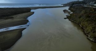
Drone video of Gualala River estuary and mouth on Nov. 17, 2025. River mouth is open after heavy rain. Drone video courtesy of Bonny Dunn.
Read More »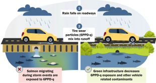
November 18, 2025For immediate release from Friends of Gualala RiverContact: Laura Baker, 510-684-4572, Lbake66@aol.com With the return of fall storms, Friends of Gualala River in partnership with The Stream Team and other volunteers have launched their second season of testing Gualala stormwater for a potent toxic chemical found in tire grit. The chemical is extremely hazardous to salmonids, especially coho …
Read More »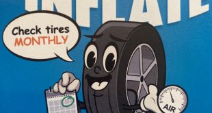
Tires treated with 6PPD (which becomes 6PPD-Q) will be with us for a very long time before manufacturers find new alternatives and old tires are removed from the environment. These toxic compounds will continue to affect human health and the health of the environment for decades to come. But in the meantime, here are a few simple steps that you …
Read More »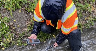
May, 2025 by Timmarie Hamill, Director, The Stream Team Brief summary: “The results suggest runoff pollution primarily originates from gas stations, parking lots, and Highway 1. For instance, 6PPD-q levels ranged from 71 to 179 ng/L at the Gas Station, Parking Lot, and Footbridge sites, compared to 14 to 28 ng/L at the Above Trinks site. Zinc levels followed a …
Read More »May, 2025 by Greg Kamman, Professional Geologist & Certified Hydrogeologist Brief Summary: “Because the Project schedule is advancing quickly, we recommend that the Friends of Gualala River convene a meeting with Caltrans and cbec to discuss the findings and conceptual BMP recommendations presented herein. Given The Stream Team’s water quality monitoring expertise and experience in pollutant reduction BMP design, we …
Read More »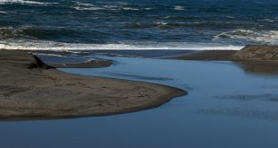
Thursday, November 13, 2025 at noon: Gualala River lagoon is full to the brim after heavy rain and before the mouth opens. Thursday, November 13, 2025 at noon: Gualala River mouth is still closed after heavy rain. The river mouth started to breach around at 5 pm Thursday, on a rising high tide, which equalizes tide and lagoon water levels …
Read More »
Join us for a community event celebrating the Gualala River and connect with those who are working to protect it. The event is organized by the Redwood Coast Land Conservancy. When: Saturday, October 11, 2025 from 1:00 – 4:00 p.m. Where: Gualala Arts Center, 46501 Old State Highway, Gualala, CA 95445 Stop by educational booths to connect with state, federal, …
Read More »
photo credit: Apple On September 23, 2025, Apple announced a new investment in the restoration and sustainable management of a working redwood forest in California, in collaboration with The Conservation Fund. The forest project is part of the company’s expanded Restore Fund initiative, which is now invested in two dozen conservation and regenerative agriculture projects that span six continents. With …
Read More »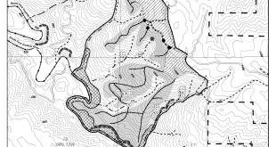
The 289-acre Lucas Point timber harvest plan (THP 1-25-00099-SON) is a revised version of the Bootleg THP (1-20-00293-SON), located in the Middle South Fork of the Gualala River watershed, south of Stewarts Point and adjacent to Tin Barn Road. The Bootleg THP was successfully challenged by Friends of the South Fork Gualala. Sonoma County Superior Court found that the Bootleg …
Read More »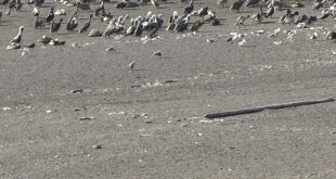
Gualala River barrier beach, September 12, 2025 (pelicans in the distance) Close-up of the pelicans Photos courtesy of Jeanne Jackson
Read More »
Gualala Redwood Timber’s 356-acre Pepper Timber Harvest Plan (THP 1-25-00093-SON) is located on steep slopes above the south side of the Wheatfield Fork of the Gualala River, approximately one mile northeast of Valley Crossing (confluence of the South and Wheatfield Forks). The plan was approved by Cal Fire on August 27, 2025. This plan is a partial successor to the …
Read More »
July 15, 2025 by Dylan Freebairn-Smith Friends of Gualala River Introduction Next week, at long last, the public will have the opportunity to offer comment on preliminary steps being taken to reduce sediment pollution washing into the Gualala River, which has been harming endangered coho salmon and threatened steelhead. Nearly thirty years after the river was first listed as impaired, …
Read More »
Introduction The North Coast Regional Water Quality Control Board is proposing to develop a new water quality permit that will apply to landowners with rural roads in the Gualala River Watershed. The permit, also referred to as “order” or “project” in this Initial Study, will require landowners to maintain their roads to reduce erosion and sediment discharges to watercourses. Landowners …
Read More »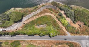
The China Gulch culvert under Highway 1 at the intersection of Old State Highway in Gualala is failing, causing a sinkhole to form at the intersection, and so it needs to be replaced promptly. CalTrans has approved $9.9M for emergency repair, and hopes to complete repairs by the end of November, 2025. China Gulch culvert, west side of Highway 1, …
Read More »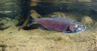
In 1994, the entire Gualala River watershed was listed on section 303(d) of the federal Clean Water Act as impaired for excessive sedimentation / siltation. Excessive sediment in the Gualala River watershed impairs Beneficial Uses associated with the Gualala River’s salmonid fishery and habitat. In 2001, the U.S. Environmental Protection Agency (EPA) established a Total Maximum Daily Load (TMDL) for …
Read More »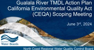
Download a pdf version of this presentation Staff Presentation Project Goals, History, and Timeline Purpose of CEQA Scoping Meeting Project Location: Gualala River Watershed Overview Gualala River Sediment Total Maximum Daily Load (TMDL) What is a TMDL? Problem Statement Water Quality Objectives Source Analysis Load Allocations Existing Programs of Implementation Potential Additional Implementation Actions Public Comments: CEQA Scoping of Possible …
Read More »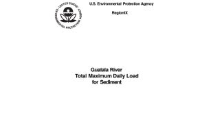
Download a pdf version of the main TMDL document This Gualala River Total Maximum Daily Load (TMDL) for sediment is prepared as part of a Clean Water Act program to assure that State water quality standards are achieved and beneficial uses protected. Protection of cold water fish such as coho and steelhead from human caused erosion of sediment is the …
Read More »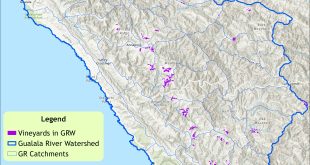
Vineyards in the Gualala River watershed Download a high resolution version of this map
Read More »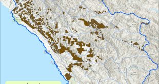
Timber Harvest Plans in the Gualala River Watershed which completed logging 1997 – 2023 Download a high resolution version of this map
Read More »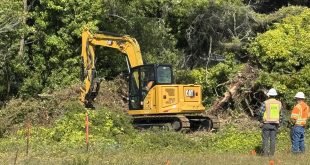
The China Gulch culvert under Highway 1 at the intersection of Old State Highway in Gualala is failing, causing a sinkhole to form at the intersection, and so it needs to be replaced promptly. CalTrans has approved $9.9M for emergency repair, and hopes to complete repairs by the end of November, 2025. For more information, see: Sinkholes and Salmon May …
Read More »