Where has the water gone
in the Wheatfield Fork of the Gualala River?
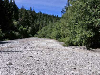
According to the rainfall totals this year reported in the Independent Coast Observer, total rainfall for Annapolis in 2008 (50.56 inches) closely matched the 8-year average of 51.90 inches. Friends of the Gualala River (FoGR) members have been shocked by the anomalous, dry gravel bed of the Wheatfield Fork in Annapolis. Pool levels have dropped far below those of extreme drought years at alarming rates – some dropping two and a half feet in July alone.
So why has the Wheatfield Fork of the Gualala River dried up to small, isolated, shallow pools below the Annapolis Road bridge at Clark’s Crossing (Stewart’s Point-Skaggs Spring Road intersection)? And why have the river’s pools remained normal and stable upstream of Clark’s Crossing?
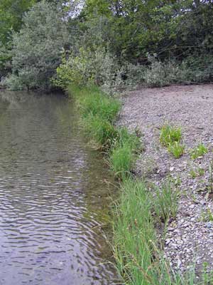
FoGR members became alarmed by the second year in a row of sudden, severe drawdown of channel pools, and the dramatic appearance of localized river drought in a normal rainfall year. Volunteers sampled preliminary data on the pool depth, and the fall in water surface level relative to the June-July wetted edge of pools (marked by an even-aged narrow band of dense marsh vegetation, torrent sedge).
Data were collected on August 19, 2008. Data compared the river reaches on deep gravel (few boulders and bedrock outcrops) downstream of the Clarks Crossing bridge, versus reaches with frequent boulders and predominant bedrock outcrops. We also photo-documented sites of data sampling, and photographed upstream reaches where we did not have foot access to the river, but had visual access from Stewart’s Point-Skaggs Springs Road.
Here is an overview of our findings, presented as a photographic tour of the Wheatfield Fork on August 18 and 19, 2008, with narrative presentation of our pool measurements.
How does the Wheatfield Fork look
upstream of Annapolis Road?
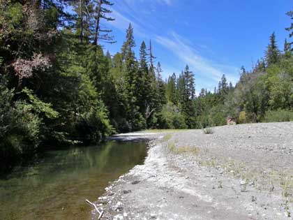
Normal! The river along Stewarts Point-Skaggs Springs Road above the boulder and bedrock bend in the river (just east of the bridge) is very different from the dry reach downstream along Annapolis Road. The river upstream of the bend is a mix of persistent wide channel pools and emergent gravel bars. The pools here show only a normal gradual and slow summer drawdown of pool water levels, just over half a foot to a little less than a foot (20-29 cm).
The normal pattern of summer low flows and gradual, partial drawdown of persistent pools that occupy much of the thalweg (the deepest part of the channel) were evident for miles above and below the YMCA camp. Here are some views of the Wheatfield Fork in this reach from August 18th, 2008.
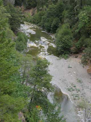
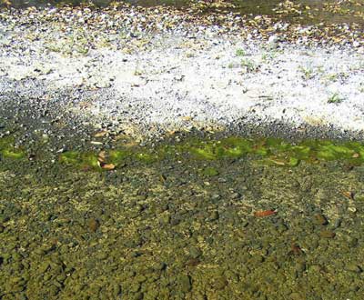
Wheatfield Fork upstream of the YMCA Camp Gualala, viewed from a pull-out: wide channel pools are fringed with wet emergent algal mats (olive green) and sun-bleached dried algal mats (white) along the pool edges, with a band of torrent sedge seedlings a short distance above the algal-matted pool bed. A high percentage of the channel bed is wetted, and indicators of very shallow pool drawdown, on the order of 20 cm (about normal) are prevalent. Note the large number of large boulders and bedrock outcrops along the bank. Friends of the Gualala River did not have foot access to this reach to measure pool water depths or seasonal changes in level.
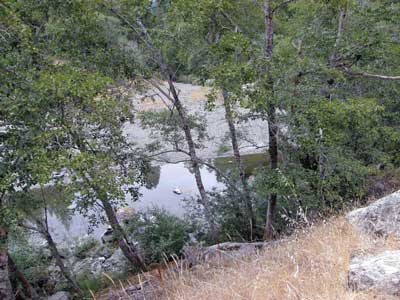
Another example of a full meander pool on August 18th, 2008, near the YMCA camp, viewed from a pull-out. The pool is wide and deep, occupying much of the channel cross-section.
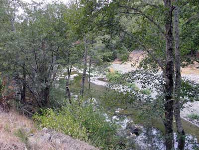
Another boulder-strewn reach of the Wheatfield Fork below the YMCA camp on August 18th, 2008, viewed from a pull-out upstream of Annapolis, with wide full pools occupying much of the low-flow channel.
How does the Wheatfield Fork look
downstream of the Annapolis Road Bridge,
below Annapolis Road?
Drained dry. Most of the channel is either dry gravel or sun-bleached algal mats where the river normally sustains channel pools all summer, including swimming holes. Channel pools that normally remain wide and deep all summer are either desiccated or reduced to shallow, warm, narrow puddles with crowded tadpoles and Gualala roach (warm-water minnows). Steelhead are gone.
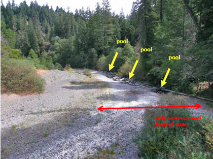
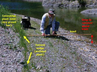
August 19, 2008 view of the Wheatfield Fork immediately upstream of the Annapolis Road Bridge at Clark’s Crossing (intersection of Stewarts Point-Skaggs Spring Road). Yellow arrows mark the remaining channel pools. The white coating on the gravel below the gravel vegetation is sun-bleached algal (Cladophora) matting, marking the position of recent shallow flowing water (riffle) in June and July. The red double arrow marks the wetted channel bed of early summer.
We measured the elevation difference between the June-July summer low-flow water surface (marked by the band of marsh vegetation above dried algal mats) and the current water surface in remaining pools (arrow). Maximum pool depth is reduced to 30 to 60 centimeters (about 1.5 to 2 feet) in pools that usually are about 100 to 130 cm deep. The vertical drop in summer water levels between June and August was 85 cm (nearly 3 feet), exposing most of the river bed.
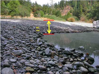
A close-up of the drained pool upstream of the bridge on August 19, 2008, with only about a foot of water remaining in the traditional summer swimming hole. The drop in water level between the current pool surface and the June-July low water line (marked by a dense band of marshy torrent sedge seedlings) is 85 cm – close to 3 feet.
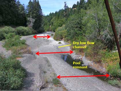
August 19, 2008 view of the Wheatfield Fork immediately downstream of the Annapolis Road Bridge at Clark’s Crossing (intersection of Stewarts Point-Skaggs Spring Road). Only one narrow shallow (50 cm maximum depth) warm pool with surviving crowded tadpoles, stickleback, and Gualala Roach persists in this formerly abundant steelhead pool. The white coating on the gravel bed is sun-bleached algal matting, marking the position of recent flowing (riffle) shallow water in June and July. The red double arrow marks the wetted channel bed of early summer. The nearest pool is at the next bend in the background; the rest of the channel is dry.
We measured the elevation difference between the June-July summer low-flow water surface (marked by the band of marsh vegetation above dried algal mats) and the current water surface in remaining pools (arrow). Maximum pool depth is reduced to 45 centimeters (about 1.5 to 2 feet). The vertical drop in summer water levels between June and August was also 85 cm (about 2.5 feet), exposing most of the river bed.
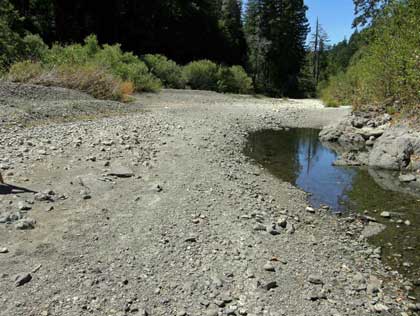
A close-up showing the remains of the former steelhead pool below the Annapolis Road Bridge, August 19, 2008.
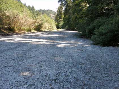
The Wheatfield Fork upstream of Haupt Creek on August 19, 2008 – bed of the low-flow channel is completely dry in August for the first time. The entire surface is covered with sun-bleached desiccated algal mats.

The Wheatfield Fork downstream of Haupt Creek on August 19, 2008 – bed completely dry for the first time by August, where pools and riffles normally last all summer and fall. Most of the bed is covered with sun-bleached desiccated algal mats.
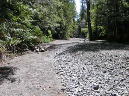
The view upstream along Haupt Creek above its confluence with the Wheatfield Fork. The entire lower creek bed is dry – no pools or fish. Lower Haupt Creek supported abundant juvenile (first and second year) steelhead in 2007, but these were also killed during sudden, rapid drawdown and drainage in mid-summer, controlled by the rapid drop in water levels of the Wheatfield Fork.
This is the long and usually wide and deep meander bend pool below the pumps that supply the Kashia Pomo community with water, a short distance downstream from the mouth of Haupt Creek. It was only a maximum of 50 cm (about 1 and ½ feet) deep on August 19, 2008. Despite the low flow summer discharge of Haupt Creek, we measured the summer drop in water level at the intake here at 45 cm (just under 1 and ½ feet). We found no steelhead left in this pool, just Gualala roach and stickleback. The downstream end below the intake is popular for swimming, but it could only support wading this summer.
Ecological indicators of low-flow
|
Why has the river gone dry along
Annapolis Road but not upstream?
Friends of the Gualala River is investigating the causes of the apparently localized dewatering of the Gualala River in 2008, when local rainfall was close to average. We first observed fluctuating water levels in 2007, but not in time to collect preliminary data to alert resource and regulatory agencies, or hire hydrologists. To our knowledge, no State or Federal agency, or nonprofit organization, has collected data or analyzed this local “river drought.”
Friends of the Gualala River looks to the North Coast Watershed Assessment Program – Gualala River Watershed Assessment Report (March 2003), prepared by California Resources Agency and California Environmental Protection Agency, for guidance on water demand and water supply in the Gualala River. We cite the NCWAP-Gualala report here, with emphasis added on key points.
Gualala River Watershed Assessment Report
|
Any water extraction from surface or groundwater supplies, depending on the amount, location and season, can affect streamflow, water quality, and consequently, fish habitat. (NCWAP p. 3-5) Based on existing water rights, land use data and observations by CDFG staff during their stream field surveys conducted from June-November 2001, current [2002] water diversions within the watershed do not appear to significantly affect streamflows, but most actual diversions or resulting streamflow reductions have not been recorded. (NCWAP-Gualala p. 3-5) Current [2002] low-flow constraints in the Gualala River will most likely prohibit future additional SWRCB appropriative water allocations . . .Unregulated water rights or illegal extraction of water may, at times, have an adverse impact on fish habitat and should be monitored. (NCWAP-Gualala p. 3-6). Table 3-2
|
Friends of the Gualala River has noted that 2001-2002 followed a long period of above-average rainfall), and agricultural expansion in Annapolis has increased significantly since 2002, when vineyard acreage was estimated to be only 700-1000 acres.
NCWAP-Gualala assessed vineyard water usage rates:
Gualala River Watershed Assessment Report
|
DWR land and water use staff have estimated the annual maximum direct application of water by drip systems for vineyards within the basin is about 9 inches per acre during the dry months of April through October. Assuming 1000 acres of vineyards [2002], the potential instantaneous peak water demand for irrigation coud reach 27 cfs [cubic feet per second flow rate] and greater than 100 cfs for frost protection . . . the use of water for these purposss may be required for a majority of the acres during prolonged dry periods or extreme frost events and could have a significant effect on streamflow (NCWAP-Gualala Appendix 1, p. 24). Any water extraction from surface or groundwater supplies, depending on the amount, location, and season, can affect streamflow, water quality, and consequently fish habitat. (NCWAP-Gualala Appendix 1, p. 25). |
Friends of the Gualala River (FoGR) strongly agrees with NCWAP’s conclusion that “Any water extraction from surface or groundwater supplies, depending on the amount, location, and season, can affect streamflow, water quality, and consequently fish habitat.”
FoGR strongly agrees with NCWAP’s recommendation that “Unregulated water rights or illegal extraction of water may, at times, have an adverse impact on fish habitat and should be monitored.”
Here’s a quick view of the damning and very official NMFS opinion on water diversions:
National Marine Fisheries Service
Findings on Gualala River Gravel Mining
August 18, 2008
|
DIVERSIONS AND DEFICIENT FLOWS OF THE GUALALA RIVER Lack of summer flow within the Gualala River appears to be an increasing problem over the last 20 years according to J.W. Dehaven (2004). Stream surveys conducted throughout the Gualala river watershed by Dehaven in the summer of 2004 noted that surface flows in streams have been reduced compared to conditions observed during extensive surveys conducted in 1976-1977. Dehaven (2004) states that summer drying of fourth and fifth order streams was both surprising and disturbing because 2004 was a normal water year in which he observed streamflows lower than during the historic drought of 1976-77. Reduction in surface flow that has been documented in the Gualala River watershed likely affects the action area of the Wheatfield Fork and South Fork Gualala River, thereby reducing the rearing space available for the summer rearing of salmonids. (p. 29) Water Diversions Summer flow in the Gualala River has been identified as a limiting factor for salmonid production (Higgins 1997, Dehaven 2004)… Intensive logging and roading, along with recently developed vineyards in the Gualala River Watershed are likely responsible for reduced summer flows that have been noted by biologists conducting surveys during the summer months. Roading and logging change the annual hydrograph by removing forest cover, allowing more runoff during storm events and less water stored in watershed groundwater supplies for release during summer flows (McDonald et al. 1991). …Very low summer flow conditions were noted by Dehaven in the extreme drought condition years of 1976-77 in larger streams of the Gualala River watershed. Three decades later many reaches of the same larger streams were observed to be dry even in normal water years, resulting in the loss of summer rearing habitat, which is attributed to increased water diversions (both legal and illegal) and other anthropogenic activities (Dehaven 2004). (pp. 33-34) The development trend in Gualala River basin has been an overall increase in permanent residences… This is likely to continue… As the human population in Gualala River basin increases, so too will the demand for water. Both authorized and unauthorized withdrawal of water from riparian wells (and potentially from wells throughout the watershed) for residential or agricultural use can lower groundwater levels and thus reduce contribution of cold groundwater flows to surface water, and decrease the level of or eliminate surface water flows, particularly during the summer months when flow is at a minimum. (p. 42) Conversion of timber lands to new vineyard development in the basin are of particular concern for both sediment runoff and water usage because agricultural water use is highest during summer, when sufficient flow is essential for providing rearing space and ameliorating high temperatures. (p. 42) Reduced summer flows throughout the watershed due to human uses and the likely effect of logging on the annual hydrograph have greatly diminished the amount of suitable rearing habitat and are likely affecting the quality of the rearing habitat in the Gualala River Lagoon during the summer through reduced freshwater inflows. (p. 43). |
FoGR will work with State and Federal regulatory and resource agencies, and independent academic and consulting scientists, to determine the causes of the anomalous localized dewatering of the Gualala River Wheatfield Fork in Annapolis, and to implement feasible and enforceable corrective actions.
See also:
Upper reaches have water – and fish In Buckeye Creek, water is flowing continuously and steelhead are abundant – unlike the de-watered lower reaches of this summer’s Wheatfield and South Forks.
Gualala River: Going, going . . . gone Channel pools in the Gualala River continued to diminish unevenly in late summer. The areas of strongest pool drawdown and dewatering are in the vicinity of water-demanding land uses (vineyards, gravel wells associated with mining and timber harvest, and commercial water trucking) adjacent to deep gravels.
 Water hits the road in Annapolis
Water trucks become a common sight in Annapolis during summer months as wells and reservoirs run dry in this water scarce area.
Summertime Dewatering: Slow but Sure Death to the River! As summer progressed, more and more main-stem, downstream reaches have developed intermittent surface flows characterized by a series of slowly drying pools, or worse – up to hundreds of linear feet of stream without any surface flow at all!
 Friends of Gualala River Protecting the Gualala River watershed and the species living within it
