Friends of Gualala River Protecting the Gualala River watershed and the species living within it
Channel pools in the Gualala River continued to diminish unevenly in late August and early September, 2008.

Friends of the Gualala River (FoGR) has observed “hot spots” of exaggerated pool drawdown relative to early summer low flow water levels are the vicinity of Valley Crossing and Clarks Crossing to Haupt Creek’s mouth. Water levels dropped by THREE FEET or more in these areas, but about one to one and one half foot along most other deep-gravel reaches of the river.
Deep river pools that have always been refuges for steelhead trout have dropped to shallow, warm puddles that support only stickleback, roach, and yellow-legged frog tadpoles. Some pools have become so warm and shallow that all fish have died, leaving only maturing tadpoles that can gulp air at the water surface.
Families of juvenile and adult river otters have been moving systematically down the Wheatfield Fork in early September, feasting on the concentrated catch of surviving fish and tadpoles. They leave turbid silt-churned waters after otter family “feeding frenzies,” and few fish.
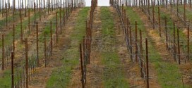
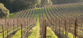
The uneven nature of the “river drought” is troubling. The areas of strongest pool drawdown and dewatering are in the vicinity of water-demanding land uses (vineyards, gravel wells associated with mining and timber harvest, and commercial water trucking) adjacent to deep gravels.
No government agencies monitor groundwater levels after permits are issued for water-demanding changes in land uses. River reaches with deep gravel beds have surface flows connected to below-bed (hyporhoeic) flows and groundwater tables. NCWAP – Gualala has identified agricultural water use (legal or illegal surface diversions or wells) as the greatest water diversion demand on the Gualala River.
The National Marine Fisheries Service (NMFS) recently concluded that low flow deficiencies on the Gualala River are in general primarily the cumulative impact of expanding vineyard conversion (water consumption and altered runoff, groundwater recharge rates) and logging (modified runoff, groundwater recharge rates); see: NMFS: Findings on Gualala River Gravel Mining [excerpts].
It is significant that the drawdown of upper Gualala River and tributaries with bedrock beds rather than deep gravel alluvium have maintained pool and channel water levels with only moderate, normal seasonal fall in water levels since early summer — less than a foot. Bedrock-controlled channels are less susceptible to the effects of falling groundwater levels.

The willows planted by Matrix of Change (a local nonprofit organization) earlier this decade at Valley Crossing (north bank of South Fork) were intended to improve channel structure and habitat quality. The willows have thrived, but there is no water in the channel that usually flows all summer. August 28, 2008.

No swimming this year in the foot-deep remnant of the large pool below the confluence of the Wheatfield and South Forks at Valley Crossing. The line of stranded wetland vegetation (torrent sedge; yellow arrow) marks the position of the early summer low-flow water level, below which gravel is coated with a white film of sun-bleached desiccated algal mats. The drop in water level here was nearly 3 feet by August 28, 2008, the date of this photo. An active gravel “sump” water intake for industrial and commercial use is a few hundred feet downstream. August 28, 2008. (View upstream to the South Fork).

The end of the Wheatfield Fork, below Twin Bridges. There is no surface flow and almost no surface water — just a hot, shallow stagnant pool with stickleback and a few roach, where steelhead in recent weeks had taken refuge. Old mature tussocks of torrent sedge jut out of the bed, with over two feet of old roots scoured out and exposed, showing that the channel bed is not filling with gravel, but eroding down — which should make deeper pools, not shallower pools. An active gravel “sump” water intake for industrial and commercial use is a few hundred yards downstream. August 28, 2008. View upstream to the Wheatfield Fork bridge.

Only a half-mile upstream of Valley Crossing, on the Wheatfield Fork, a slow-flowing channel reach shows only moderate drawdown of water levels — about one foot — and persistent low flow. This is the same day as the Valley Crossing photo above – August 28, 2008.

Clark’s Crossing, Wheatfield Fork (Annapolis Road Bridge at Stewarts Pt. – Skaggs Springs Road) August 31, 2008 – the few pools measured in mid-August are nearly gone, reduced to narrow puddles in the scour-shadow of boulders. View upstream from the bridge.

August 31, 2008. The last channel pool (yellow arrow) below the bridge has shrunk to about ¼ the area it occupied two weeks earlier. This shallow (less than 1 foot deep) puddle lost all remaining fish (roach and stickleback), leaving only yellow-legged frog tadpoles gulping for air in warm, shallow oxygen-deficient water. The river is all dry gravel here. The largest vineyard in Annapolis is located upslope. We have no information on the location of wells near this channel reach, but immediately upstream, on bedrock river bed, the river still maintains fish and flows.


Comparison of mid-August (8/12/08) and late August (8/31/08) pool size below the bridge at Clarks Crossing, Wheatfield Fork.

A large pool formed around natural old-growth redwood rootwads and boulders between the bridge and Haupt Creek is usually three feet deep and supports steelhead and roach even in dry years. August 31, 2008 – the dry pool banks are bleached white, and less than foot of water stands on the bottom, supporting only roach.
See also:
Upper reaches have water – and fish
 In Buckeye Creek, water is flowing continuously and steelhead are abundant – unlike the de-watered lower reaches of this summer’s Wheatfield and South Forks.
Where has the water gone?
 In the summer of 2008, the Wheatfield Fork of the Gualala River dried up to small, isolated, shallow pools below the Annapolis Road bridge while the river’s pools remained normal and stable upstream.
 Water hits the road in Annapolis
Water trucks become a common sight in Annapolis during summer months as wells and reservoirs run dry in this water scarce area.
Summertime Dewatering: Slow but Sure Death to the River!
 As summer progressed, more and more main-stem, downstream reaches have developed intermittent surface flows characterized by a series of slowly drying pools, or worse – up to hundreds of linear feet of stream without any surface flow at all!