Friends of Gualala River Protecting the Gualala River watershed and the species living within it
Historical Proposals
1955 – Sonoma County Planning Commission
Revised Beach and Shoreline Master Plan
- Priority 1 – F. Gualala Riverbank and coastal shoreline.
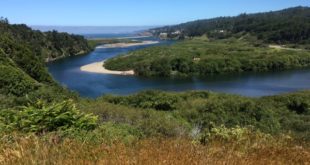
“This area is proposed for a major park because of its size, its natural beauty of second growth timber and other foliage, and because of its location along the Gualala River and the south fork. There are sandy beaches and many good campsites along the riverbank. The area would provide an excellent site for a major state park. The general area proposed is a strip about 1,100 feet wide including the fork of the river and including Valley Crossing to the intersection of the North Fork, then a continuing strip about one-fourth mile either side of the main stream extending to the ocean. There are approximately 1,500 acres of land in these strips, with nearly 10 miles of river frontage. An old railroad right-of-way which is now a road gives access to the area from the county road at Valley Crossing and also at the highway near the north county line.” (p. 7)

1989 – Sonoma County General Plan
(Open Space Element, Section 4.1)
- Gualala River Waterway Trail.
“The Gualala River is a navigable waterway and as such, public access is protected by Article XV, Section 2 of the California Constitution. The trail follows the river from the Sonoma / Mendocino county line to Stewart’s Point Road.”

– click to enlarge –
1999 – Sonoma County Local Coastal Plan Revisions
DRAFT revised 6/99
V-15
- Gualala River Forest Trail – Proposed
Discussion: “A trail paralleling the Gualala River was recommended as part of the Gualala Point County Park Plan. Owners of Gualala Redwoods proposed to make available to County Parks the opportunity to construct and operate a loop trail which could be moved by logging operations as required.”Recommendations:
“Negotiate with landowner to acquire public use of a trail. Construct trail – no new support facilities needed.”Acquisition Priority: II Development Priority: II
“Note: (April 6, 1982) Accessways 5 through 9 have been modified to reflect the provisions of the Bane Bill. Litigation is pending challenging the Constitutionality of this legislation. If litigation results in invalidating the Bane Bill, the County will immediately initiate a Coastal Plan Amendment to reinstate the Coastal Plan access provisions originally adopted by the Board of Supervisors.”
2003 – Sonoma County Outdoor Recreational Plan
Proposed Regional Open Space Parks
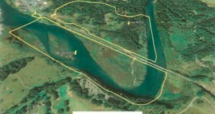
OS-1 Gualala Point Regional Park Expansion
(detailed recent color map depicts river park extending length of South Fork, to near Salt Point Horseshoe Cove addition)
Chapter 6, p. 93 (recommendations):
- Expand Gualala Point Regional Park (OS1)
“The expansion of Gualala Point Regional Park would increase the access to the Gualala River and adjacent redwood groves for fishing, hiking, camping, and wildlife viewing. This need has been identified by recreational plans, the Coastal Plan, and in the Plan workshops. This expansion may include approximately 50 acres of land contiguous top the existing County Park.”
- Gualala River Waterway Trail (A)
“The Gualala River is a navigable waterway and as such, public access is protected by Article XV, Section 2 of the California Constitution. The trail follows the river from the Sonoma / Mendocino county line to Stewart’s Point Road. This project was recommended at the public workshops.”