Friends of Gualala River Protecting the Gualala River watershed and the species living within it
There is a lot that Ric Davidge and his groups are keeping quiet about their proposed Gualala River water bag project.
An interesting way to start is by taking a look at his application to the California Division of Water Rights. It is simply amazing… much of it is hand written and totally illegible. How can DWR evaluate something it can’t even read? How can the public possibly respond to it?
Alaska Water claims that they will simply be taking water from the river mouth just before it runs into the ocean. In fact the Gualala estuary is a complex environment, part salt, part fresh and in their fine print Alaska Water states that they need to go at least a quarter mile above the highest point of salt water intrusion, which would put their water collection facility between half a mile and a mile upstream of the Hwy 1 bridge.
Alaska Water also claims that they will only be taking water from the river gravel bed aquifer and not impacting free flowing river water levels. This of course is total nonsense. The 170 cubic feet per second extraction rate that Alaska Water proposes for a single collection cistern is many times more than the relatively small Gualala gravel aquifer could ever carry in any season. Their system would in fact be totally open to and dependent on capture of surface flow.
By way of comparison the Sonoma County Water Agency operates five huge Ranney type collectors buried deep in the gravel beds near the Wohler Bridge on the Russian River. The peak capacity of all five collectors combined is 180 cfs. The Russian River middle reach gravel aquifer is over a mile wide and the SCWA must still use both a river dam and five large infiltration ponds (which must be bulldozed clear of silt every summer) to provide each Ranney Collector with adequate flow!
Alaska Water is also using some pretty optimistic numbers as far as total river flow, taken during some historically wet years between 1951 and 1971. The river’s watershed is much different now. The river rises quickly during a rain but the water levels subside almost as quickly when the rain stops. In the past well timbered slopes absorbed and slowly released rain water; now clearcuts and channelized streams allow instant runoff.
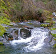
The Gualala is not a healthy river. It has been badly impacted by the huge loads of sediments released into the river and its creeks by logging activities. The river had never recovered from the catastrophic 1964 flood which completely filled many upper creeks with soil washed off of clearcut slopes. A new round of accelerated clearcutting beginning in the 1990s has made things worse.
These sediments and other logging related impacts have reduced the number of deep pools that can shelter fish, reduced the amount of shade cover over the river and caused the water temperatures along parts of the Gualala and tributary creeks to be too high to support salmon in the summer.
Juvenile steelhead generally spend their first year in tributary streams and some intact portions of the main river and then move down into the estuary region for a season or more before going out to sea. In the estuary the gradient mix of salt and fresh water helps them to gradually acclimate to salt conditions.
Evidence suggests that juvenile steelhead in the Gualala move down to the estuary unusually early in their life cycle, probably due to a deficiency of suitable deep shaded pools upstream.
The problem is the estuary itself isn’t what it used to be, and it is getting worse. At one time there was a commercial shipyard on the Gualala estuary, located just to the west of the Mendocino side of the Hwy 1 bridge. They were able to build, launch and float large ocean going lumber schooners in what was then a wide deep estuary and take them out of the river mouth during high water. Now most of the estuary is choked with shallow sand and gravel bars.
Measurements show that the Gualala River estuary is still in a state of aggradation as the pulses of sediment released by past timber operations work their way down the river over a period of years. This is one reason that Gualala Aggregates is allowed to skim gravel from bars above the estuary.
Given time the estuary and the river can recover. During high water sediment will be flushed from the river and the estuary, deep pools will once again form and new trees will grow to shade the stream. Evidence shows that this has happened before. The river was badly damaged by the initial logging operations in the late 1800s and substantially recovered before the second round of logging began in the 1950s.
Alaska Water’s proposed operations would end an essential part of that recovery and would be the final nail in the coffin for the Gualala estuary and the steelhead population. There will always be at least some tributary streams and portions of the river that will provide suitable spawning beds and pools… but all of the salmon are at some point in their lives totally dependent on what is left of the estuary.
The Gualala River simply doesn’t have 170 cfs of water that it can afford to give. Six months a year (May though October) that is actually more than the average daily flow. Three months a year it would be 50 to 100 percent of the total flow (November, March, April) and even during the peak flow months of December-February it still amounts to nearly 20 percent of all the water in the river.
Alaska Water’s removal of most of the fresh water in the Gualala River well upstream of the estuary will greatly reduce the flushing of the estuary in the wettest months leading directly to increased sediment buildup and the destruction of critical estuary habitat. In the winter there will be fewer days when the river mouth is open and in the summer we will be left with a silted-in estuary, filled with warm salt water and totally incapable of supporting juvenile salmon.
[An earlier version of this article appeared in the Independent Coast Observer on April 5, 2002.]