Friends of Gualala River Protecting the Gualala River watershed and the species living within it
Water hits the road in Annapolis
What’s that sucking sound?
Water hits the road in Annapolis, on its way to a vineyard that was permitted by the state without adequate on-site water supply.

Water hits the road in Annapolis
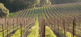
Irrigation needs in warm weather (and for spring frost control) strain inadequate wells and storage capacity, so owners turn to the local streams and the Gualala River to bail them out. Water is reportedly drawn from streamside wells, in-stream reservoirs and directly drafted using truck mounted pumps.
According to the Gualala River Watershed Assessment Report (NCWAP-Gualala, 2003), some of this drafting is legal and some may not be. All of it could have a significant impact on natural systems, according to the consensus of State resource agencies that participated in NCWAP-Gualala.
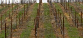
In this case, water is trucked from a local stream source some miles away from the eventual destination, a vineyard with 5,000-gallon plastic water tanks perched along a roadside vineyard ridge. No county tank permits were required to review environmental and viewshed impacts, due to an exemption for tanks under 5,000 gallons. This probably explains why twenty five of these tanks were eventually put in place.

|
Many vineyard permit applications reviewed by Friends of the Gualala River state that they will not affect stream flows because they get all their irrigation water by capturing rainfall and runoff in reservoirs in winter. But none of them has affirmed or verify that they never supplement their irrigation supplies in dry years with well water or shallow gravel aquifer water connected to tributaries or the river. The sight of water trucks commuting all day between vineyards and the vicinity of creeks in summer raises our suspicions about how much vineyard irrigation depends directly or indirectly on streams. We can see only the trucks that carry water to vineyards across Annapolis Road. But what about the majority of vineyards on the downslope side of Annapolis Road? |

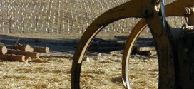
Water trucks become a common sight in Annapolis during summer months, as wells and reservoirs run dry in this county-recognized Class IV water scarce area.
Further commercial agriculture project development will only worsen the impacts of this water drafting during summer months, when fish and other aquatic species struggle to survive in disappearing streams and a river impacted by low summer flows, high temperatures, and a man-made excessive gravel bed load.
In addition, vineyards bring drains, reservoirs, and conversion of dense forest which make land that would otherwise be a seasonably wet sponge stay relatively unsaturated. Winter flows get drained off quickly with an increased flash flooding risk. Slow seeping of this cool, stored water into the streams and river during the summer months is crucial for the survival needs of countless fish, insects, amphibians, and other living animals and plants.
Too many straws in this impacted river will spoil the chances of recovery.

See also:
Upper reaches have water – and fish In Buckeye Creek, water is flowing continuously and steelhead are abundant – unlike the de-watered lower reaches of this summer’s Wheatfield and South Forks.
Gualala River: Going, going . . . gone Channel pools in the Gualala River continued to diminish unevenly in late summer. The areas of strongest pool drawdown and dewatering are in the vicinity of water-demanding land uses (vineyards, gravel wells associated with mining and timber harvest, and commercial water trucking) adjacent to deep gravels.
Where has the water gone? In the summer of 2008, the Wheatfield Fork of the Gualala River dried up to small, isolated, shallow pools below the Annapolis Road bridge while the river’s pools remained normal and stable upstream.
Summertime Dewatering: Slow but Sure Death to the River! As summer progressed, more and more main-stem, downstream reaches have developed intermittent surface flows characterized by a series of slowly drying pools, or worse – up to hundreds of linear feet of stream without any surface flow at all!
More information on water resource issues in Sonoma County:
- Grand Jury report, 2003-2004
- General Plan Update, Water Resources Element