Friends of Gualala River Protecting the Gualala River watershed and the species living within it
Fluctuating Water Levels?
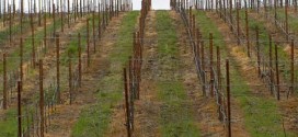
Below is a photo from the September 14, 2007 edition of the Independent Coast Observer (Gualala) showing the unusual / unprecedented drying of the Gualala River Wheatfield Fork below Clark’s Crossing (Annapolis Road bridge), directly above the “vineyard alley” of Annapolis.

Photo by Will Guyan, published in the 9/14/07 ICO. Wheatfield Fork Gualala River below Clark’s Crossing, view upstream to Annapolis Rd Bridge. Pools are essentially gone.
In August, 2007, the water levels on the Gualala Wheatfield Fork in Annapolis downstream of Clark’s Crossing fluctuated both up and down by as much as 10 inches (probably more), and rather suddenly. The drawdowns aren’t surprising, but the sudden increases in water level are very suggestive of intermittent pulses of water diversion or well pumping in river gravels, and at a time of vineyards’ irrigation demand.
 August 11, 2007, ANOMALY – Sun-bleached white algal mats are re-submerged by mysterious RECENTLY RISING water levels, too fast for new algae to grow. Dark areas of pool are living algal mats, outlining the pool edge at the time of maximum drawdown, when the rest of the bed’s algal mat was desiccated and bleached white in the sun.

August 12, 2007. Note the extent of the recent and rapidly re-submerged sun-bleached white algal crust (no new algal growth) and the dark live algal crust. Note also the extent of the flooded bed.
Annapolis locals see water trucks ‘commuting’ along the east end of Annapolis Road. We can see the irrigation systems to newly planted vines, and we find it difficult to believe that the water demand is all supplied by the rain-fed irrigation ponds for the long, dry summer – especially the water demand from the extensive new vineyards that are establishing young vines.
The 2-foot deep pools in Haupt Creek above its mouth went dry within a 3 week period from late July to early August, killing all steelhead – hundreds in the 3 to 6 inch range. About the same time, a big sandy swimming hole on the Wheatfield Fork above the Annapolis Road bridge suddenly dropped by about 8 inches between successive weekends.

August 19, 2007. Note that the channel pool is desiccated and bleached white by the sun, only one week after the bed was extensively submerged. Water level dropped about 10 inches in one week, after rising.

August 19, 2007 – Torrent sedge seedlings outline mid-summer water line. Note sun-bleached white algal mats on gravel, and residual pool.
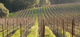
Interestingly, the bedrock-bed reaches of the Wheatfield Fork (structural grade control, no deep alluvium) above Clark’s Crossing were relatively stable in water level (only minor drawdown), and were flooded bank to bank in many segments – and they still are, even in mid-September.
 where the bed is cut into impervious bedrock.")
July 28, 2007. Wheatfield Fork, Gualala River, about one quarter mile upstream from Clark’s Crossing (Annapolis Road Bridge) where the bed is cut into impervious bedrock. The river is flooded bank to bank, about one to three feet deep. Note the contrast in water depth and channel flooding downstream of the bridge, where gravel is deep and can be affected by subsurface pumping. The channel here remains flooded as of mid-September.
| See also: 2008: Where has the water gone? |