Friends of Gualala River Protecting the Gualala River watershed and the species living within it
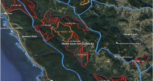
Logging proposed near river banks
Gualala Redwoods, Inc., which manages 35,000 acres of the Gualala River watershed in northwest Sonoma and southwest Mendocino Counties, has proposed two plans that combined would cut trees in 400 acres next to the river. The “Lily” plan proposes logging along the North Fork and Little North Fork, while the “Iris” plan proposes logging along the South Fork of the Gualala River. Both of these plans, if approved, would greatly distress the already impaired river and its threatened and endangered fish species.
 The “Lily” plan is almost identical to the “Cassidy” plan that raised a large public outcry when it was proposed four years ago. According to the National Marine Fisheries Service, the Regional Water Quality Control Board, and the California Department of Forestry, the Cassidy plan would have seriously impacted the recovery efforts of coho salmon and steelhead trout, which are listed as threatened under the federal Endangered Species Act. Consequently, the Department of Forestry denied the Cassidy plan, and when Gualala Redwoods appealed to the California Board of Forestry, the Board upheld that denial.
Gualala Redwoods has sued the Department and Board of Forestry [February 2006: the court denies Gualala Redwoods’ petition], and has now submitted the plan again under the name “Lily.” The facts on the ground haven’t changed – the trees near the river’s edge are large, and would generate a profit for the company, but the river is still impaired by excess sediment and high temperatures that threaten the survival of coho and steelhead. The plan should again be denied, according to the National Marine Fisheries Service, the Department of Fish & Game, and the Regional Water Board. The “Iris” plan, a similar plan on the South Fork, should be denied for the same reasons.
Why are floodplain logging plans being proposed?
Throughout northern California, timber companies such as Gualala Redwoods, Inc., are proposing to cut trees alongside rivers, tributaries, and streams.
The areas near a river’s edge are called riparian zones. In the low-lying valleys of a watershed, riparian zones are prone to flooding. Floodplains are ecologically rich areas that protect the health of a river and the many creatures whose lives depend on the river. While selective floodplain logging is permissible under current regulations, timber companies have rarely proposed cuts within these sensitive areas. Regulations state that watercourse vegetation shall be protected and remain standing to the degree necessary to protect scenic and natural qualities and to protect the beneficial uses of water.
Timber companies are proposing to cut within these flood-prone riparian areas for several reasons: excessive historical cutting and sheer economics. The areas alongside rivers contain some of the most productive timber remaining in coastal northern California. The trees are larger not only because they receive generous amounts of water, but also because these trees have been considered off limits since the passage of California’s Forest Practices Act thirty years ago, and have grown older and larger.

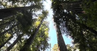
Thin riparian strip of trees |
Many of the riparian strips bordering rivers have been left alone as protective measures to mitigate the effects of nearby upland clearcuts (see photo). In other words, nearby clearcuts were approved in part on the understanding that the riparian buffer is an important ecological feature that would remain undisturbed.From an economic standpoint, it is easy to understand why timber companies are targeting the short-term profits to be gained from riparian or floodplain logging. However, the long-term impacts should be reason for pause.
Examples of riparian strips being maintained as a condition of approval for timber harvest plans adjacent to the riparian buffer of the Gualala River and its tributaries:
THP 1-97-392 (Buckwheat): “Timber harvest plans in the recent past have not had trees removed from the WLPZs [watercourse and lake protection zone – essentially a riparian strip or buffer] where such removal could lead to reduced shade canopy.” – memo 10/10/97 to Glen Newman from the Department of Forestry (CDF).
THP 1-97-477 (Rockeye): As a result of the designation of coho as an endangered species, additional mitigations were deemed necessary for the Class I WLPZ. The shade canopy protection for the 1st 25 feet of the Class I was increased to 85% of canopy retention and the rest of the WLPZ increased to 70%. The mitigations were incorporated to “protect [coho] habitat from siltation, loss of woody debris, and temperature increases resulting from removal of canopy cover.” (John Williams letter to Dennis Hall – CDF in response to pre-harvest inspection).
THP 1-96-276 (German Rancho 96): The registered professional forester for the German Rancho plan states the large woody debris recruitment near watercourses will be from streamside conifers and hardwoods which would be retained in the WLPZs.
THP 1-96-373 (Powerline): In a memo from the Department of Forestry to Glen Newman, “The WLPZ areas of cable class I watercourses were examined where the RPF [registered professional forester] had noted the reduction in zone width allowed for cable operations on steep slopes. Although the RPF had noted this would be done, the zone maintained a 100-150+ WLPZ in the steeper areas. The zone in the less steep areas was also generously flagged to provide an adequate buffer. The Class I watercourse, Rockpile and Buckeye Creeks, are both believed to have warm water temperatures that could act to reduce the aquatic habitat quality in those streams. This office has asked for WLPZ no-cuts on THPs in these drainages for about 2-3 years.”
“Because the proposed harvest plan may be within the ranges of several species which have been listed as threatened under the Endangered Species Act, including the Central California Coast Steelhead, Central California Coast coho, and California Coastal Chinook the protection of the WLPZ would seem ever more necessary. The Department of Fish and Game has also determined there is potential marbled murrelet habitat on and adjacent to the proposed THP. These areas of species recovery take precedent to the proposed timber management operations.”
Trees Keep the River Cool
Riparian buffers and floodplains in low-lying valleys provide many ecological benefits. They preserve water quality for aquatic life, recreation, and other beneficial uses. Riparian areas act as filters capturing sediments and reducing nutrients and pesticides that can runoff from nearby use. Most of the rivers along the north coast are impaired due to excess levels of sediment. Reducing the vegetation alongside rivers will further diminish the filtering abilities of the riparian strip and thus the health of the rivers.
Additionally, trees near the water’s edge provide shade that keeps the water cool. With low flows in the hottest periods of the year, the shade from trees and other riparian vegetation are vital to the survival of cold-water fish such as coho salmon and steelhead trout, which are already threatened with extinction. With the removal of vegetation and canopy, temperatures can reach levels that kill fish.
Conclusion
From a short-range economic perspective, it is easy to understand the appeal in cutting large trees. Yet, it is essential to remember why these areas still have sizable trees. For 30 years, riparian areas have been recognized for their importance in maintaining biodiversity, acting as a filter for sediments and nutrients, and preserving water temperatures for fish and other water organisms. We must protect the riparian areas for the health of the rivers, its fish and other organisms, and ultimately our health as humans.