Friends of Gualala River Protecting the Gualala River watershed and the species living within it
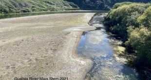
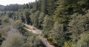
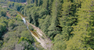
Gravel Mining and the Garcia River
Sources of Information, Problems and SolutionsPrepared for the Implementation Subcommittee of the Garcia WatershedAdvisory Group I. Sources of Information: II. Problems: Impacts of Instream GravelExtraction General Impacts of instream mining on cold water habitat; as listed in the Upper Russian River Aggregate Resources ManagementPlan for Mendocino County: A. Effects on River Stability – 2. ” Incision or headcutting in tributaries in response to a lowerbase level in the main channel.” 3. “Increased bank heights, bank erosion, and channel capacitydue to channel incision.” 4. “Threat to infrastructure such as bridges due to incisionthat undermined bridge piers or supports. … (efforts may be madeby the State to recover bridge repair costs from legally responsibleparties)” 5. “Exposure of clay substrate layer within or below graveldeposits dure to incision may remove gravel that is a necessary componentof habitat.” 6. “Incision can cause a lowering of the groundwater table inthe adjacent floodplain aquifer. This may effect local wells,reduce the aquifer storage and impact riparian vegetation by isolatingroots above the water table.” Morphological changes caused by changes to local morphology and hydrology- (M-1, M-2, M-3, M-5, M-6, M-7, M-8, M-9, M-11, M-14) 8. “Downstream channel changes including reduced sedimentsupply to downstream bars, widening and flattening of low flow channel,and increased potential for braiding.” 9. “Upstream channel changes including incision or lowering ofthe thalweg elevation due to headcutting upstream of the miningarea.” 10. “Removal of riparian vegetation reduces habitat and maycause channel instability and increase bank erosion.” 11. “Degradation of habitat from the removal of the armor layer orcoarse sediment from bars and release of fine material to the channeldownstream.” This impact is reduced but noteliminated. Two impacts listed for floodplain pit excavation are: potential forriver capture and reduction in the filtering ability of the floodplainaquifer. M-F1 to M-F8, These impacts are reduced but noteliminated. Floodplain skimming would result in temporary loss of riparianvegetation and the potential loss of stability. M-F9, impact noteliminated. B. Effects on Fishery Resources – This is a listing of themore direct impacts to fish. 1. “A reduction in salmonid spawning gravel, protective cover,food resources and deep pools if gravel is depleted at a greater ratethan it is replenished.” M-1 2. “Increased proportion of fine grain sizes.”(Relates to impact 11 above.) not fully mitigated 3. “Increased siltation.” M-6,M-9, M-10, M-11, M-13 4. “Increased water temperatures, eroded banks, and reducedfood availability, if the riparian habitat is altered and/ordestroyed.” M-9, M-11, M-12 5. “Decreased habitat for both fish and fish foodorganisms, if large woody debris and/or vegetation growing on gravel barsare removed during the annual gravel bar skimming.” M-9,M-11 6. “Diminished habitat quality (reduction in pool size)and quantity, if the stream bed geomorphology isaltered.” M-2, M-3, M-5, M-6 7. “Direct kill, if any fish are present in the excavationarea.” M-2, M-3 8. Possibility of fish stranding in off-channel pools. (paraphrased) M-4 9. “Blockage of migration of salmonids … as a result ofsummer road crossings.” M-12 10. De-watering of stream channel or inadequate water depths due towater use in gravel washing and processing. (This impact was notconsidered in the management plans but was an issue in the GualalaAggregates EIR.) M-15 C. Effects on Riparian Habitat – Coho salmon aredependent on riparian habitat. 1. “Bar skimming disturbs the existing riparian vegetation,providing opportunities for invasion by non-native species …”Mitigatable with buffer and revegetation/irradicationprogram. M-9, M-11 2. “Bar skimming mechanically removes habitat at the earlyto mid-successional stages, interrupting the natural formation oflandforms which develop habitat complexity and a diversity of ageclasses.” Even with a buffer the opportunity to build ahigher bar and establish a more complex habitat is gone. May beunmitigatable. M-9, M-11 3. “Downcutting of the river channel … can increasestream velocity and bank erosion, resulting in impacts to all habitatstages.” Mitigatable, perhaps, by limiting extraction torecruitment. M-1 4. Modification of the substrate within the zone of seedlingestablishment. “Substrate modifications of most concernare those which result in loss of gravels and exposure of the claylayer.” Largely mitigatable by extraction limitations but therestill is an unavoidable change to the substrate. M-1,M-2 5. “Terrace pit development impacts riparian habitat byremoving vegetation – often for the long term. Pits may constrain the channel, reducing the area in which a diversity of riparianhabitat stages may develop.” May be possible to mitigate throughappropriate design and conservation easements , however stream capturemust be anticipated. M-F1 Observed Gravel Extraction Impacts in the Garcia from theGarcia River Gravel Management Plan: Five sites are listed as having extensive erosion during the 1995floods. The two areas chosen to show historic changes throughsequential photographs, indicate a shifting of the low flow channel andbraiding which, it is noted, may occur because of local impacts such asremoval of vegetation or gravel. Specific examples of degradationcaused by instream mining are cited that indicateinstability: “Downstream changes such as braiding on Bar 12resulting from gravel skimming on Bar 11 were documented by Fugro West,Inc. (1994)” (page 6), “The Baxman mining operations onBar 30 resulted in reduced pool habitat quality along two stream reaches,as well as the elimination of the natural pool-riffle sequence. (Matthews, 1990)” (page 7) “Incision in the thalweg that extended through the estuarysuggests that sediment supply is insufficient to maintain the currentchannel bed elevation. “If extraction continues, incision of the thalweg is to beexpected.” Other limiting factors effecting gravel mining in the Garcia fromthe Garcia River Gravel Management Plan and other sources Temperature Impairment: III. Solutions: Mitigation for Instream GravelExtraction Solution 1: Cease Instream Mining Both management plans recommend this final solution for solving theimpacts of instream mining. The plans recommend a phase out, but itis clear that these rivers do not have the resources to maintain a viableextraction industry. OR – Solution 2: If mining continues, the following mitigationswill reduce most, but not all, of the above mentioned impacts: (allquotes are from the 7.1.1 and 7.1.2 of the URRARMP pages 61 to66, (GRGMP pages 87 to 93 is similar), unless otherwisenoted) M-1 Permit mining Volume Based on Measured AnnualReplenishment -This should be based on 50% or less of transport rateAND the actual replenishment at the site. The Gualala AggregatesEIR explains it this way. “In many cases of instream gravelmanagement, an estimate of average annual bedload transport is used todefine a “safe yield” or the volume of gravel that can besafely extracted without depleting the gravel supply in the stream andcausing channel changes and negative environmental effects and otherimpacts. This concept is not accurate in many cases, particularlyon the Garcia River, where a significant volume of bedload is notavailable for extraction and must move through the project reach toretain equilibrium channel morphology and substrate conditions. In these cases, the actual gravel replenishment rate at a particular baror for the entire project reach may be calculated with the sedimenttransport continuity equation: … Unless the sediment trapefficiency of the extraction site is 100% (not the case with bar skimmingoperations), then the bedload transport rate will always exceed actualreplenishment with the latter defined as the volume actually deposited onthe extraction site.” (page 5.2 -43, emphasis added) TheGualala Aggregates EIR further states; “A key concept of gravelreplenishment is that it must originate from sources upstream of theproject reach in order to avoid depletion of local supply. If, forexample, flood conditions are hydraulically adequate to scour the lowwater channel and riffles, but not substantial enough to mobilizeupstream sources, then gravel deposited on bars which appears asreplenishment may have come from the low water channel and riffles in theimmediate reach. Extraction of this gravel would cause a netdepletion of gravel supply in local reach. Therefore, new graveldeposits on the bar in this case would not represent actualreplenishment. Actual replenishment on gravel bars must comefrom upstream sources in order to add material to the gravel bars whilemaintaining gravel supplies and related environmental quality in the lowwater channel and riffles.” (pages 5.2-43, 44) Finallythis quote from the same source sums up the need for cross sectionsand a maximum limit to yearly extraction that is a fraction ofbedload; “Estimates of bedload transport provide only a roughestimate of the maximum volume of aggregate available eachyear on average, and as explained above, do not account for storageeffects nor year-to-year variability in flow and sedimenttransport. Because future flood events during the project lifecannot be accurately predicted, use of bedload transport as a “safeyield” is a flawed concept. Over-extraction within one reachor within the river over an extended period without floods andreplenishment can cause the greatest response and possible harm. Consequently, it is preferable to extract gravel at the actual rateof replenishment as measure by volumetric changes betweenadequately spaced topographic cross sections of the affected portions ofthe river, while not depleting local supplies. Therefore, theextraction rate should only be a fraction of the estimated annualbedload yield.” (5.2-55) M-2 Establish an Absolute Elevation below Which NoExtraction May Occur – This is known as the “redline” andit is a permanent line drawn in the gravel it does not change from yearto year. “A redline elevation should be at least one footabove the low flow water surface elevation (at the edge of the barclosest to the low flow channel) during the first year following adoptionof the gravel management plan…” To be effective, this lineshould have some hydrologic reasoning with the intent of retaining thestructure of the low flow channel and bar rather than an arbitrary lowflow measurement. “A one-foot minimum elevation as abuffer with a 4% grade toward the bank or a two-foot minimum elevationwith a 2% grade is consistent with that recommended by the NationalMarine Fisheries Service.” M-3 Limit In-channel extraction methods to “BarSkimming” or an Alternative Method Recommended by the Dataevaluation Team M-4 Grade Slope of Excavated Bar to Prevent FishEntrapment – 2 to 4 % depending on the height above the lowflowchannel M-5 Extract Gravel from the Downstream Portion of theBar – “Retaining the upstream one to two thirds of the bar andriparian vegetation while excavating from the downstream third of the baris accepted as a method to promote channel stability and protect thenarrow width of the low flow channel necessary for fish.” M-6 Concentrate Activities to Minimize Disturbance andAvoid Expansion of Instream mining Activities Upstream of River mile 3.7-mining should be concentrated to a few, already mined bars because”skimming decreases habitat and species diversity – these effectsshould not be expanded over a large portion of the study area.”.(GRGMP) In the GRGMP, Sensitive Habitat Areas were defined andidentified in section 4.26 (page 28): “Those areas which hadboth high habitat values and steelhead abundance (>100 fish) werechosen as the most sensitive areas which and are depicted in Figure4.12. These reaches included River Miles 3.9-4.4, 5.3-6.7, 7.1-7.2and 7.5-8.0.” This study also states that the mainstemupstream of Windy Hollow Road (RM 3.7) is significant to spawning. A study completed by CDFG in 1966 found that the “lower river”(below Eureka Hill Bridge) to be among the least damaged reaches of theGarcia. M-7 Review Cumulative Effects of Gravel Extraction –“The cumulative impact of all mining proposals should be reviewed onan annual basis to determine if there are potential cumulative riverineeffects and to ensure that permits are distributed in a manner thatminimizes long-term impacts and inequities in permits between adjacentmining operations.” M-8 Establish a Long-term Monitoring Program – seemonitoring program GRGMP, Chapter 8 and URRARMP Chapter 8. M-9 Evaluate Need for In-channel Reclamation on an AnnualBasis – “Currently, in-channel re-vegetation is not recommended,provided that skimming operations follow recommendations for a 2% to 4%slope (from bank to low flow channel edge) on the downstream third of thebar without depressions that could trap fish.” …”Revegetation with native species should be planted adjacent toaccess roads in the riparian zone to act as a buffer and to retain finesediment. Retention of all naturally recruited woody debris shouldbe encouraged.” In order to mitigate impact C-1 there should beincluded an irradication program for non-native, invasivespecies. M-10 Minimize Activities that Release Fine Sediment to theRiver – “No washing, crushing, screening, stockpiling, or plantoperations should occur at or below the streams ‘average high waterelevation’, or in the Russian River, the top of bank (Macedo,1995). M-11 Retain Vegetation Buffer at Edge of Water and AgainstBank – “CDFG frequently suggests a buffer of 100 feet back fromthe top of bank of the channel ( Cox, pers. comm., 1995).” Theplan also recommends a riparian buffer on the upper 1/3 to 2/3 of thebar, along the channel and the hillslope (floodplain) side. (M-3and M-5) M-12 Avoid Dry Road Crossings – “Dry roadcrossings disrupt the substrate and can result in direct mortality orincreased predation opportunity of fry. The preferred type ofcrossing is the free-span seasonal bridge (Macedo, 1996).” …”Any structure placed across a river or recreationally navigablestream should be designed and installed so as to proved sufficientoverhead clearance to allow unobstructed and safe passage for smallrecreational craft (California State Lands Commission, pers. comm.,1996).” M-13 Limit In-channel Operations to the Period BetweenJune 15 (July 15)* to October 15 “Gravel extraction foroutside this window may interfere with salmonid incubation andmigration.” *The GRGMP notes that spawning salmonids havebeen observed as late as June 2 and that the hatching period may extendfor 40 to 50 days, it must be realized that there will be impact tosalmonids with this extraction window. The start date must belatter than June 15 to avoid impact to these late spawners. M-14 An Annual Status and Trends Report Should be Producedby the County, the Data Evaluation Team or Agent of the County- results of monitoring, extraction volumes, recommendations forreclamation. M-15 Maintenance flows – Establish minimum by-pass flowat mining and processing sites. 7.1.2 Floodplain (Off-Channel) ExtractionRecommendations M-F1 Floodplain Gravel Extraction Should be SetBack from the Main Channel – The URRARMP recommends 1000 feet fromthe main channel and 400 feet from tributaries to avoid “rivercapture”. (The GRGMP recommends 400 feet.) Manyhydrologists agree that river capture in floodplain pits is inevitableand it is best to recognize this impact and mitigate for the worst casescenario. The plans also recommend (citing CDFG), that the pitsshould be designed to withstand a 100-year flood and to avoid fishstranding, the pits must be above the 25-year floodplain, however,”NMFS prefers 100-year isolation to minimize fishentrapment.” M-F2 Maximum Depth of Floodplain Gravel ExtractionShould Remain above the Channel Thalweg – this reduces the impacts ofpotential river capture and reduces impact to groundwaterquality M-F3 Side slopes of Floodplain Excavation Should Rangefor 3:1 t 10:1 M-F4 Place Stockpiled top soil above the 25-yearFloodplain M-F5 Floodplain Pits should be Restored to Wetland Habitator Reclaimed for Agriculture – “There are very few examples ofsuccessfully restored or reclaimed gravel extraction pits…”. The importation of clean, similar material to fill apit for agricultural reclamation is unlikely. M-F6 A Plan Must be Submitted Which Accounts for Long-termLiability – The impacts of floodplain pits goes far beyond theeconomic life of the operation – the general public should not bear thisburden. M-F7 Establish a Long-term Monitoring Program – tomonitor ” impacts to river stability, groundwater, fisheries, andriparian vegetation” and assess “any reclamation or restorationattempted”. M-F8 Annual Status Report – Included in the abovementioned report. M-F9 Floodplain Skimming Should only be Considered ifFuture Channel Incision Deepens the Low Flow Channel |