Friends of Gualala River Protecting the Gualala River watershed and the species living within it
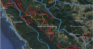
THP 1-00-484 SON – Haupt Creek
California Department of Forestry
135 Ridgway Ave.
Santa Rosa 95401
31 July 2003
Notes for 2nd Review of 1-00-484
I have been retained as a watershed specialist and professional forester to review THP 1-00-484 by the Friends of the Gualala River, the Sierra Club Redwood Chapter and Citizens for Watershed Protection. I have not been on the ground of this THP and make the following brief comments based on review of the submitted THP and addenda, RWQCB comments and DFG comments. Some of these points may have been addressed in first review and most were brought up as concerns during the first second review meeting. These points are now followed by recommendations.
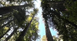
Please note that generally, this is a THP which includes steep terrain (70% plus slopes) with virtually no flattening between the harvest are and Haupt Creek. The area is old growth redwood, at this time a rare ecosystem in Sonoma, Marin and Mendocino Counties (KRIS-Gualala 2003 and NCWAP 2003). The THP watershed analysis does not recognize this unique ecosystem, nor work to mitigate its management in a cutover landscape. The potential sediment yield from this harvest is significant, due to steep slopes, questionable slope stability, untried management of old-growth redwood on steep, potentially unstable slopes, and roadbuilding on mapped landslide surfaces, unstable geologic contacts and in draws. Sediment impacts from this harvest may have profound impacts on the reduced anadramous fish populations of the Gualala River watershed.
Other concerns about this THP center around the management and location of the road system, particularly in the north, which are situated on another landowner’s property. There is no connection from that road system to either landings for cable yarding or acknowledgment of cable settings on the neighbor’s road, itself. There is significant concern that those landings are not in the THP, thus not subject to monitoring and follow-up under the Forest Practice rules, and that those roads are being developed on extremely unstable ground.
Comments:
- Acreage (p. 5). The total acreage is misstated. WLPZ harvest area has been specifically excluded from the total of 37 acres, and accounts for 12 acres of selection logging. This error has continued through the THP documents, as on the revision of 11-22-02.
- Acreage (p. 5) The total acreage does not include the area between the road on Ohlsen (to the north) and the harvest plan. The landings, cable settings and cable corridors are part of the plan; if trees are cut to facilitate logging, or yarding is occurring on this ground, they cannot be out of the plan. See also THP boundary map (p. 28). Note that Ohlsen is designated as an additional landowner for this THP, but his requirements will extend beyond road maintenance. If there is an Ohlsen THP which includes the landings and yarder settings, it must be specifically acknowledged and coordinated with this plan.
- Tractor restrictions for layouts and assist (q. 21). Here and on the map (p. 32), it is proposed that tractors will not be on excessively steep slopes and landslide areas. This is contrary to the contour intervals shown and the slope stability maps (Huffman, 1980; Fuller, Haydon et al 2002).
- Road pitch – length (p. 17). Item 24.c. is contradicted by the attached map (p. 30) which shows 500 feet of road greater than 15% (approaching 40% by contour evaluation). Please note that the proposed steep pitch is indicated to be in a swale, likely a class III channel.
- Listed Species ID (p. 22). Item 32 indicates that LTO and workers will halt work and notify DFG when a listed species is found. DFG notes that red tree voles are present on the site. No training for LTO and staff is mentioned, so there is no demonstration that workers will actually see signs of listed species.
- Silviculture and yarding (p. 28) Map continues to not indicate slide areas noted by Huffman or NCWAP, in direct opposition to CDMG recommendation (Schlosser, 2001). Huffman’s and NCWAP’s slope stability maps indicates significant slides within area, known and expected. Water Quality statements suggest erosion occurs readily on unstable ground, and slopes lead directly to the stream. Excessive sedimentation could result from an unmodified plan. Mitigations to logging on the landslide masses are suggested by CEG Schlosser (letters, 23 July and 18 Dec. 02), who recommends “at least 50% canopy” retention and cites that “slightly more than 50%” of the canopy will be retained. Department of Forestry recommends that. There is no basis for the “at least 50%” cited; the very steep (app. 90%) slopes are being eroded by Haupt Creek at their base and are designated inner gorge by NCWAP; this mitigation appears inadequate and arbitrary. CDF earlier cited Schlosser’s input (13 June 2001) as retention of 70% canopy.
- Road placement (p. 30) Roads will cross landslide areas designated by Huffman (1980) and Fuller, Haydon et al. (2002), though the plan does not acknowledge this (q. 24 i ). Additionally, the road to the north will enter and exit “Bf” delineation, “Locally level areas within hilly terrrain; may be underlain or bounded by unstable or potentially unstable rock materials.” (Huffman, 1980). This crossing of delicate, eroding boundary zones is (a) not acknowledged in the plan, (b) not delineated on the revised geologic map, (c) not mitigated in the plan and (d) an integral part of the harvest that is not included in the plan. Water Quality’s (2001) photographs show the severity of erosion at this boundary area.
- Alternatives (p. 61). Public purchase statement says this area is not unique or special. Old growth in Sonoma is extremely unusual, and the RPF needs to acknowledge this. Sources for this information are KRIS-Gualala, itself citing HSU 1986 and the US Forest Service. Comparison of these data show an apparent drop from a few percent of the watershed as ‘old growth’ to less than one percent (no data shown in USFS reporting). This site may be well worth public preservation… it is certainly rare.
- The Watershed Assessment Area is not well suited to this plan area. Comparison of WAA map (p. 64) with CDF’s watershed delineation (in: Cafferata, 2003) show divergence in outline of the planning watershed. The planning watershed, in addition, includes areas outside of Haupt Creek watershed, diluting the impact of this plan for analysis purposes.
- This plan is in a watershed strongly affected by sedimentation. Water Quality photos (2001, in: KRIS-Gualala) show massive aggradation and sedimentation, effectively drying the stream in places. The NCWAP analysis of this watershed indicates it was worse and is better, though data are old and unapproved by peer review or CDF process (LP-SYP data, in: NCWAP 2003). There is no indication that sedimentation in Haupt Creek approaches a ‘natural’ rate, much less a net-zero-discharge-minus rate to allow recovery.
Recommendations:
- Evaluate landslide potential using Montgomery and Dietrich’s slope stability model, as has already been prepared for the site by the Gualala KRIS project, and restrict harvesting areas, road construction or reconstruction to areas that are determined stable.
- Determine the validity of 50% harvest on landslides, and give the public a referenced reason to accept or reject this recommendation.
- Mitigate road crossings of “Bf” (potentially unstable at boundary edges) slope stability boundary on Ohlsen (northern) part of plan and road system.
- Limit heavy equipment as in § 914.2 (f)(1)(iii) with regard to ‘slopes > 50% which lead without flattening…’ The southern portion of the plan appears to contradict this rule on the THP map.
- Remeasure distance of road slope already noted as >15% to ensure no pitches longer than 500 feet.
- Redraw Watershed Assessment Area to encompass upstream watershed on Haupt Creek and exclude areas outside of watershed.
- Identify methodology for protecting Sonoma Tree Voles, either by training tree markers, tree fallers or using an independent biologist.
- Expand THP boundary to include landings and setups for cable area on Ohlsen, to the north. Notify Ohlsen of responsibility respective to Forest Practice Rules.
These comments are respectfully submitted for comment. If you have questions or wish further information, please contact me at 707.433.5544
Sincerely,
Fred Euphrat, Ph.D. RPF 2365
for Friends of the Gualala River, Sierra Club Redwood Chapter and Citizens for Watershed Protection.
References
Cafferata, Peter. 16 June 2003. Hydrologic Review.
CDF, 2003. Northcoast Watershed Assessment Program (NCWAP).
Fuller, Haydon et al. 2002. Slope Stability map. in: CDF, 2003.
Northcoast Watershed Assessment Program (NCWAP).
Huffman, M. 1980. Geology for Planning in Sonoma County, Slope Stability Map. CDMG Special Report 120.
KRIS-Gualala Information System, 2003. www.krisweb.com A multiagency data project in association with the HSU Institute for Forest Resources.
Richardson, Charles, 2001 et seq. THP 1-00-484 and updates, file literature and correspendence.